You are here: Home > Network List > GM - US Geological Survey Networks Stations List
> Station NMP45 New Mexico Permian - Site# W4S5 > Earthquake Result Viewer
NMP45 New Mexico Permian - Site# W4S5 - Earthquake Result Viewer
| Earthquake location: |
Samoa Islands Region |
| Earthquake latitude/longitude: |
-15.7/-172.5 |
| Earthquake time(UTC): |
2022/12/04 (338) 19:24:27 GMT |
| Earthquake Depth: |
148 km |
| Earthquake Magnitude: |
6.9 Mi |
| Earthquake Catalog/Contributor: |
NEIC PDE/at |
|
| Network: |
GM US Geological Survey Networks |
| Station: |
NMP45 New Mexico Permian - Site# W4S5 |
| Lat/Lon: |
32.33 N/103.58 W |
| Elevation: |
1127 m |
|
| Distance: |
81.4 deg |
| Az: |
53.033 deg |
| Baz: |
245.368 deg |
| Ray Param: |
0.04729003 |
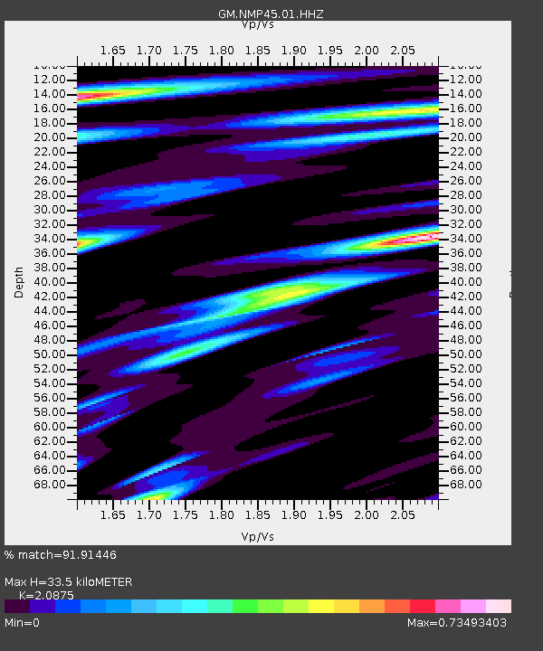
| Estimated Moho Depth: |
33.5 km |
| Estimated Crust Vp/Vs: |
2.09 |
| Assumed Crust Vp: |
6.129 km/s |
| Estimated Crust Vs: |
2.936 km/s |
| Estimated Crust Poisson's Ratio: |
0.35 |
|
| Radial Match: |
91.91446 % |
| Radial Bump: |
400 |
| Transverse Match: |
82.88711 % |
| Transverse Bump: |
400 |
| SOD ConfigId: |
29823551 |
| Insert Time: |
2022-12-18 20:04:03.512 +0000 |
| GWidth: |
2.5 |
| Max Bumps: |
400 |
| Tol: |
0.001 |
|

Signal To Noise
| Channel | StoN | STA | LTA |
| GM:NMP45:01:HHZ:20221204T19:35:56.034973Z | 4.479735 | 1.0824865E-6 | 2.4164075E-7 |
| GM:NMP45:01:HHN:20221204T19:35:56.034973Z | 0.9199357 | 1.353445E-7 | 1.4712386E-7 |
| GM:NMP45:01:HHE:20221204T19:35:56.034973Z | 1.8897734 | 2.933198E-7 | 1.5521428E-7 |
| Arrivals |
| Ps | 6.1 SECOND |
| PpPs | 17 SECOND |
| PsPs/PpSs | 23 SECOND |


