You are here: Home > Network List > GS - US Geological Survey Networks Stations List
> Station MCA04 MCA04, Monte Cristo Range, NV > Earthquake Result Viewer
MCA04 MCA04, Monte Cristo Range, NV - Earthquake Result Viewer
| Earthquake location: |
Samoa Islands Region |
| Earthquake latitude/longitude: |
-15.7/-172.5 |
| Earthquake time(UTC): |
2022/12/04 (338) 19:24:27 GMT |
| Earthquake Depth: |
148 km |
| Earthquake Magnitude: |
6.9 Mi |
| Earthquake Catalog/Contributor: |
NEIC PDE/at |
|
| Network: |
GS US Geological Survey Networks |
| Station: |
MCA04 MCA04, Monte Cristo Range, NV |
| Lat/Lon: |
38.08 N/117.71 W |
| Elevation: |
1662 m |
|
| Distance: |
74.2 deg |
| Az: |
42.09 deg |
| Baz: |
234.891 deg |
| Ray Param: |
0.05215348 |
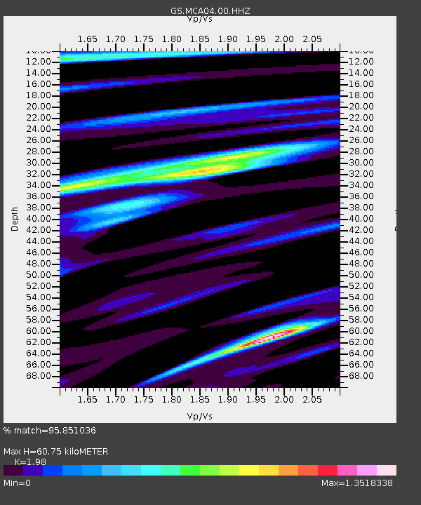
| Estimated Moho Depth: |
60.75 km |
| Estimated Crust Vp/Vs: |
1.98 |
| Assumed Crust Vp: |
6.276 km/s |
| Estimated Crust Vs: |
3.17 km/s |
| Estimated Crust Poisson's Ratio: |
0.33 |
|
| Radial Match: |
95.851036 % |
| Radial Bump: |
370 |
| Transverse Match: |
93.57153 % |
| Transverse Bump: |
400 |
| SOD ConfigId: |
29823551 |
| Insert Time: |
2022-12-18 20:04:20.521 +0000 |
| GWidth: |
2.5 |
| Max Bumps: |
400 |
| Tol: |
0.001 |
|

Signal To Noise
| Channel | StoN | STA | LTA |
| GS:MCA04:00:HHZ:20221204T19:35:16.278992Z | 23.296326 | 2.4812573E-6 | 1.0650852E-7 |
| GS:MCA04:00:HH1:20221204T19:35:16.278992Z | 1.6087604 | 3.4353988E-7 | 2.1354323E-7 |
| GS:MCA04:00:HH2:20221204T19:35:16.278992Z | 2.525664 | 5.4068005E-7 | 2.1407442E-7 |
| Arrivals |
| Ps | 9.8 SECOND |
| PpPs | 28 SECOND |
| PsPs/PpSs | 38 SECOND |


