You are here: Home > Network List > IW - Intermountain West Stations List
> Station LOHW Long Hollow, Wyoming, USA > Earthquake Result Viewer
LOHW Long Hollow, Wyoming, USA - Earthquake Result Viewer
| Earthquake location: |
Samoa Islands Region |
| Earthquake latitude/longitude: |
-15.7/-172.5 |
| Earthquake time(UTC): |
2022/12/04 (338) 19:24:27 GMT |
| Earthquake Depth: |
148 km |
| Earthquake Magnitude: |
6.9 Mi |
| Earthquake Catalog/Contributor: |
NEIC PDE/at |
|
| Network: |
IW Intermountain West |
| Station: |
LOHW Long Hollow, Wyoming, USA |
| Lat/Lon: |
43.61 N/110.60 W |
| Elevation: |
2121 m |
|
| Distance: |
81.7 deg |
| Az: |
40.354 deg |
| Baz: |
239.164 deg |
| Ray Param: |
0.047070738 |
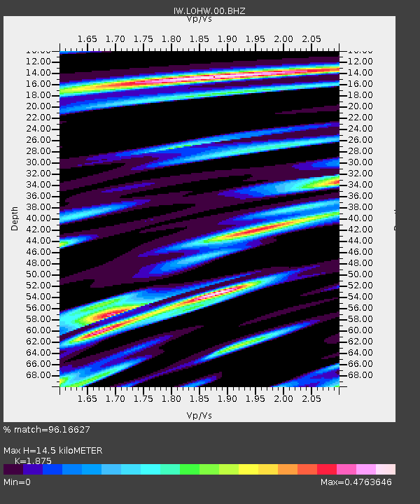
| Estimated Moho Depth: |
14.5 km |
| Estimated Crust Vp/Vs: |
1.88 |
| Assumed Crust Vp: |
6.207 km/s |
| Estimated Crust Vs: |
3.31 km/s |
| Estimated Crust Poisson's Ratio: |
0.30 |
|
| Radial Match: |
96.16627 % |
| Radial Bump: |
385 |
| Transverse Match: |
91.540085 % |
| Transverse Bump: |
400 |
| SOD ConfigId: |
29823551 |
| Insert Time: |
2022-12-18 20:06:18.822 +0000 |
| GWidth: |
2.5 |
| Max Bumps: |
400 |
| Tol: |
0.001 |
|

Signal To Noise
| Channel | StoN | STA | LTA |
| IW:LOHW:00:BHZ:20221204T19:35:57.700012Z | 12.719953 | 2.22678E-6 | 1.7506197E-7 |
| IW:LOHW:00:BH1:20221204T19:35:57.700012Z | 2.464653 | 4.418384E-7 | 1.7927003E-7 |
| IW:LOHW:00:BH2:20221204T19:35:57.700012Z | 3.3014903 | 6.440126E-7 | 1.9506724E-7 |
| Arrivals |
| Ps | 2.1 SECOND |
| PpPs | 6.6 SECOND |
| PsPs/PpSs | 8.7 SECOND |


