You are here: Home > Network List > XA95 - Missouri to Massachusetts Transect Stations List
> Station MM13 Spiceland, Indiana > Earthquake Result Viewer
MM13 Spiceland, Indiana - Earthquake Result Viewer
*The percent match for this event was below the threshold and hence no stack was calculated.
| Earthquake location: |
Colombia |
| Earthquake latitude/longitude: |
5.1/-75.7 |
| Earthquake time(UTC): |
1995/08/19 (231) 21:43:32 GMT |
| Earthquake Depth: |
125 km |
| Earthquake Magnitude: |
6.1 MB, 6.6 UNKNOWN, 6.5 MW |
| Earthquake Catalog/Contributor: |
WHDF/NEIC |
|
| Network: |
XA Missouri to Massachusetts Transect |
| Station: |
MM13 Spiceland, Indiana |
| Lat/Lon: |
39.83 N/85.31 W |
| Elevation: |
337 m |
|
| Distance: |
35.7 deg |
| Az: |
347.244 deg |
| Baz: |
163.405 deg |
| Ray Param: |
$rayparam |
*The percent match for this event was below the threshold and hence was not used in the summary stack. |
|
| Radial Match: |
92.32455 % |
| Radial Bump: |
400 |
| Transverse Match: |
92.121544 % |
| Transverse Bump: |
400 |
| SOD ConfigId: |
4480 |
| Insert Time: |
2010-02-26 17:53:29.842 +0000 |
| GWidth: |
2.5 |
| Max Bumps: |
400 |
| Tol: |
0.001 |
|
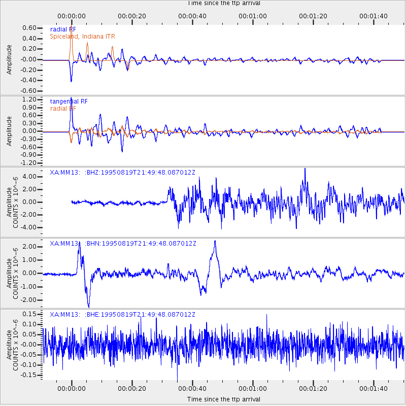
Signal To Noise
| Channel | StoN | STA | LTA |
| XA:MM13: :BHN:19950819T21:49:48.087012Z | 19.431232 | 9.555492E-7 | 4.917595E-8 |
| XA:MM13: :BHE:19950819T21:49:48.087012Z | 1.0127249 | 3.8858705E-8 | 3.8370445E-8 |
| XA:MM13: :BHZ:19950819T21:49:48.087012Z | 6.012878 | 9.827922E-7 | 1.634479E-7 |
| Arrivals |
| Ps | |
| PpPs | |
| PsPs/PpSs | |


