You are here: Home > Network List > N4 - Central and EAstern US Network Stations List
> Station P46A Rosedale, IN, USA > Earthquake Result Viewer
P46A Rosedale, IN, USA - Earthquake Result Viewer
| Earthquake location: |
Samoa Islands Region |
| Earthquake latitude/longitude: |
-15.7/-172.5 |
| Earthquake time(UTC): |
2022/12/04 (338) 19:24:27 GMT |
| Earthquake Depth: |
148 km |
| Earthquake Magnitude: |
6.9 Mi |
| Earthquake Catalog/Contributor: |
NEIC PDE/at |
|
| Network: |
N4 Central and EAstern US Network |
| Station: |
P46A Rosedale, IN, USA |
| Lat/Lon: |
39.62 N/87.21 W |
| Elevation: |
194 m |
|
| Distance: |
96.3 deg |
| Az: |
50.759 deg |
| Baz: |
254.961 deg |
| Ray Param: |
0.04043398 |
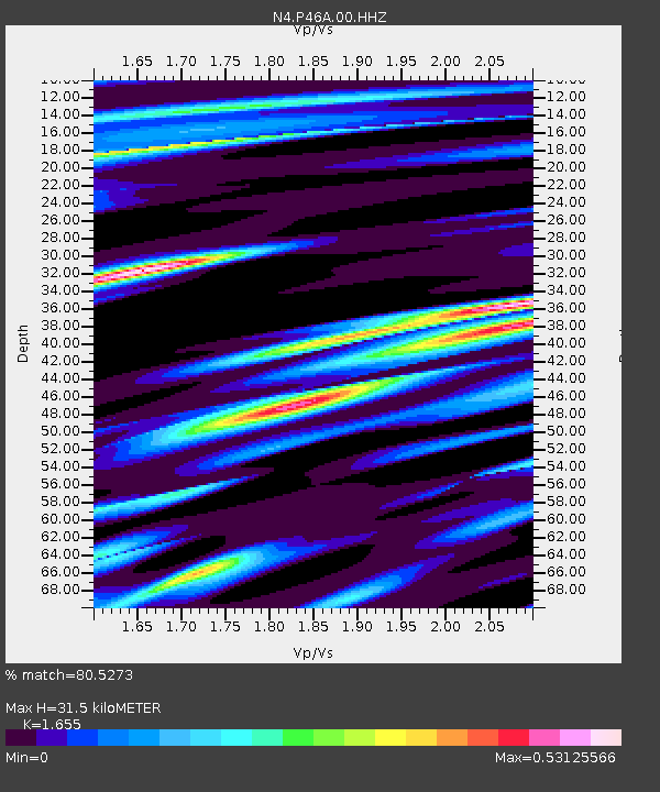
| Estimated Moho Depth: |
31.5 km |
| Estimated Crust Vp/Vs: |
1.65 |
| Assumed Crust Vp: |
6.444 km/s |
| Estimated Crust Vs: |
3.894 km/s |
| Estimated Crust Poisson's Ratio: |
0.21 |
|
| Radial Match: |
80.5273 % |
| Radial Bump: |
400 |
| Transverse Match: |
58.418087 % |
| Transverse Bump: |
400 |
| SOD ConfigId: |
29823551 |
| Insert Time: |
2022-12-18 20:08:13.896 +0000 |
| GWidth: |
2.5 |
| Max Bumps: |
400 |
| Tol: |
0.001 |
|

Signal To Noise
| Channel | StoN | STA | LTA |
| N4:P46A:00:HHZ:20221204T19:37:07.258972Z | 3.2314806 | 9.543681E-7 | 2.9533462E-7 |
| N4:P46A:00:HH1:20221204T19:37:07.258972Z | 2.130837 | 6.215338E-7 | 2.9168527E-7 |
| N4:P46A:00:HH2:20221204T19:37:07.258972Z | 1.5669429 | 3.600454E-7 | 2.2977568E-7 |
| Arrivals |
| Ps | 3.3 SECOND |
| PpPs | 13 SECOND |
| PsPs/PpSs | 16 SECOND |


