You are here: Home > Network List > NN - Western Great Basin/Eastern Sierra Nevada Stations List
> Station MCA06 Monte Cristo ASL 06 > Earthquake Result Viewer
MCA06 Monte Cristo ASL 06 - Earthquake Result Viewer
| Earthquake location: |
Samoa Islands Region |
| Earthquake latitude/longitude: |
-15.7/-172.5 |
| Earthquake time(UTC): |
2022/12/04 (338) 19:24:27 GMT |
| Earthquake Depth: |
148 km |
| Earthquake Magnitude: |
6.9 Mi |
| Earthquake Catalog/Contributor: |
NEIC PDE/at |
|
| Network: |
NN Western Great Basin/Eastern Sierra Nevada |
| Station: |
MCA06 Monte Cristo ASL 06 |
| Lat/Lon: |
38.01 N/117.88 W |
| Elevation: |
1462 m |
|
| Distance: |
74.0 deg |
| Az: |
42.065 deg |
| Baz: |
234.778 deg |
| Ray Param: |
0.052257124 |
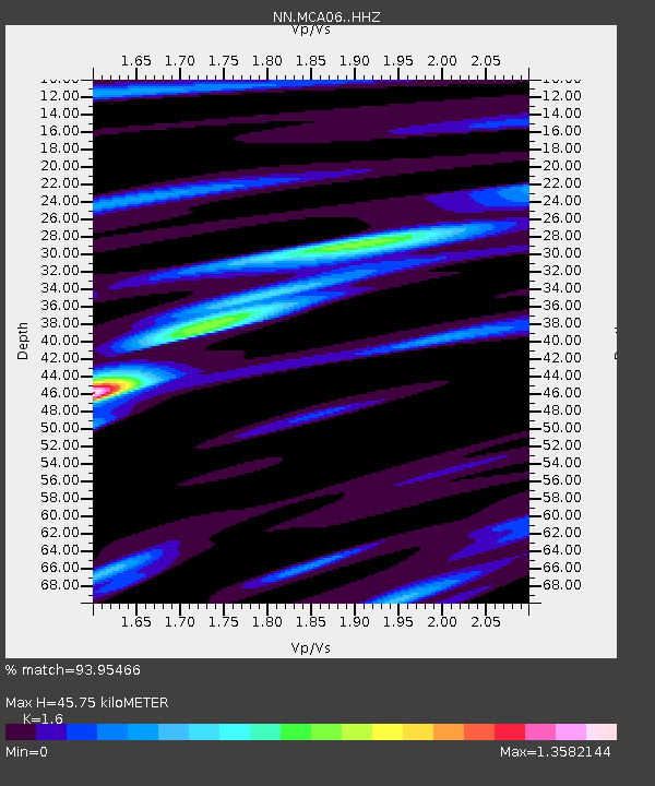
| Estimated Moho Depth: |
45.75 km |
| Estimated Crust Vp/Vs: |
1.60 |
| Assumed Crust Vp: |
6.276 km/s |
| Estimated Crust Vs: |
3.922 km/s |
| Estimated Crust Poisson's Ratio: |
0.18 |
|
| Radial Match: |
93.95466 % |
| Radial Bump: |
378 |
| Transverse Match: |
91.04948 % |
| Transverse Bump: |
400 |
| SOD ConfigId: |
29823551 |
| Insert Time: |
2022-12-18 20:10:02.095 +0000 |
| GWidth: |
2.5 |
| Max Bumps: |
400 |
| Tol: |
0.001 |
|

Signal To Noise
| Channel | StoN | STA | LTA |
| NN:MCA06: :HHZ:20221204T19:35:15.405029Z | 15.589122 | 2.4466924E-6 | 1.569487E-7 |
| NN:MCA06: :HHN:20221204T19:35:15.405029Z | 3.6721861 | 5.1880227E-7 | 1.4127885E-7 |
| NN:MCA06: :HHE:20221204T19:35:15.405029Z | 5.357194 | 6.505909E-7 | 1.2144247E-7 |
| Arrivals |
| Ps | 4.5 SECOND |
| PpPs | 18 SECOND |
| PsPs/PpSs | 23 SECOND |


