You are here: Home > Network List > NN - Western Great Basin/Eastern Sierra Nevada Stations List
> Station PNT Pine Nut, Nevada w84 > Earthquake Result Viewer
PNT Pine Nut, Nevada w84 - Earthquake Result Viewer
| Earthquake location: |
Samoa Islands Region |
| Earthquake latitude/longitude: |
-15.7/-172.5 |
| Earthquake time(UTC): |
2022/12/04 (338) 19:24:27 GMT |
| Earthquake Depth: |
148 km |
| Earthquake Magnitude: |
6.9 Mi |
| Earthquake Catalog/Contributor: |
NEIC PDE/at |
|
| Network: |
NN Western Great Basin/Eastern Sierra Nevada |
| Station: |
PNT Pine Nut, Nevada w84 |
| Lat/Lon: |
39.09 N/119.60 W |
| Elevation: |
2076 m |
|
| Distance: |
73.5 deg |
| Az: |
40.332 deg |
| Baz: |
233.227 deg |
| Ray Param: |
0.052565135 |
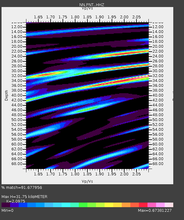
| Estimated Moho Depth: |
31.75 km |
| Estimated Crust Vp/Vs: |
2.10 |
| Assumed Crust Vp: |
6.279 km/s |
| Estimated Crust Vs: |
2.993 km/s |
| Estimated Crust Poisson's Ratio: |
0.35 |
|
| Radial Match: |
91.677956 % |
| Radial Bump: |
400 |
| Transverse Match: |
85.141846 % |
| Transverse Bump: |
400 |
| SOD ConfigId: |
29823551 |
| Insert Time: |
2022-12-18 20:10:11.701 +0000 |
| GWidth: |
2.5 |
| Max Bumps: |
400 |
| Tol: |
0.001 |
|

Signal To Noise
| Channel | StoN | STA | LTA |
| NN:PNT: :HHZ:20221204T19:35:12.752991Z | 10.267053 | 2.3115738E-6 | 2.251448E-7 |
| NN:PNT: :HHN:20221204T19:35:12.752991Z | 1.4189662 | 3.7772895E-7 | 2.6620012E-7 |
| NN:PNT: :HHE:20221204T19:35:12.752991Z | 2.6791193 | 7.8279294E-7 | 2.9218293E-7 |
| Arrivals |
| Ps | 5.7 SECOND |
| PpPs | 15 SECOND |
| PsPs/PpSs | 21 SECOND |


