You are here: Home > Network List > O2 - Oklahoma Consolidated Temporary Seismic Networks Stations List
> Station CHAN Chandler, Oklahoma, USA > Earthquake Result Viewer
CHAN Chandler, Oklahoma, USA - Earthquake Result Viewer
| Earthquake location: |
Samoa Islands Region |
| Earthquake latitude/longitude: |
-15.7/-172.5 |
| Earthquake time(UTC): |
2022/12/04 (338) 19:24:27 GMT |
| Earthquake Depth: |
148 km |
| Earthquake Magnitude: |
6.9 Mi |
| Earthquake Catalog/Contributor: |
NEIC PDE/at |
|
| Network: |
O2 Oklahoma Consolidated Temporary Seismic Networks |
| Station: |
CHAN Chandler, Oklahoma, USA |
| Lat/Lon: |
35.65 N/96.79 W |
| Elevation: |
266 m |
|
| Distance: |
87.9 deg |
| Az: |
52.165 deg |
| Baz: |
249.073 deg |
| Ray Param: |
0.042693526 |
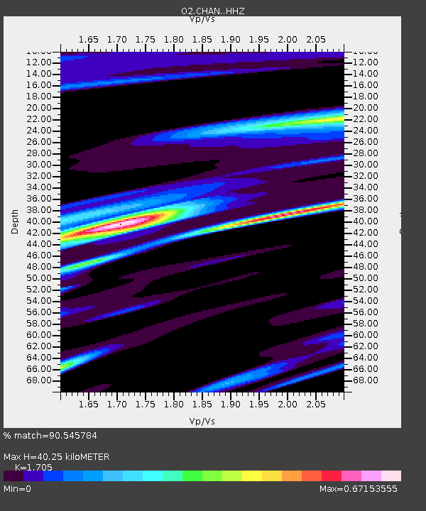
| Estimated Moho Depth: |
40.25 km |
| Estimated Crust Vp/Vs: |
1.71 |
| Assumed Crust Vp: |
6.426 km/s |
| Estimated Crust Vs: |
3.769 km/s |
| Estimated Crust Poisson's Ratio: |
0.24 |
|
| Radial Match: |
90.545784 % |
| Radial Bump: |
353 |
| Transverse Match: |
89.6933 % |
| Transverse Bump: |
400 |
| SOD ConfigId: |
29823551 |
| Insert Time: |
2022-12-18 20:11:26.309 +0000 |
| GWidth: |
2.5 |
| Max Bumps: |
400 |
| Tol: |
0.001 |
|

Signal To Noise
| Channel | StoN | STA | LTA |
| O2:CHAN: :HHZ:20221204T19:36:28.434998Z | 5.987289 | 1.5304349E-6 | 2.55614E-7 |
| O2:CHAN: :HHN:20221204T19:36:28.434998Z | 0.7501686 | 3.5934318E-7 | 4.7901653E-7 |
| O2:CHAN: :HHE:20221204T19:36:28.434998Z | 1.2585196 | 2.8853543E-7 | 2.2926574E-7 |
| Arrivals |
| Ps | 4.5 SECOND |
| PpPs | 17 SECOND |
| PsPs/PpSs | 21 SECOND |


