You are here: Home > Network List > O2 - Oklahoma Consolidated Temporary Seismic Networks Stations List
> Station KS13 South Haven SW Station, Kansas > Earthquake Result Viewer
KS13 South Haven SW Station, Kansas - Earthquake Result Viewer
| Earthquake location: |
Samoa Islands Region |
| Earthquake latitude/longitude: |
-15.7/-172.5 |
| Earthquake time(UTC): |
2022/12/04 (338) 19:24:27 GMT |
| Earthquake Depth: |
148 km |
| Earthquake Magnitude: |
6.9 Mi |
| Earthquake Catalog/Contributor: |
NEIC PDE/at |
|
| Network: |
O2 Oklahoma Consolidated Temporary Seismic Networks |
| Station: |
KS13 South Haven SW Station, Kansas |
| Lat/Lon: |
37.01 N/97.48 W |
| Elevation: |
340 m |
|
| Distance: |
87.8 deg |
| Az: |
50.697 deg |
| Baz: |
248.609 deg |
| Ray Param: |
0.04271688 |
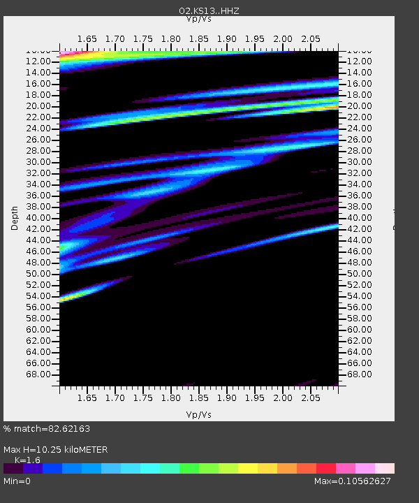
| Estimated Moho Depth: |
10.25 km |
| Estimated Crust Vp/Vs: |
1.60 |
| Assumed Crust Vp: |
6.483 km/s |
| Estimated Crust Vs: |
4.052 km/s |
| Estimated Crust Poisson's Ratio: |
0.18 |
|
| Radial Match: |
82.62163 % |
| Radial Bump: |
400 |
| Transverse Match: |
82.118454 % |
| Transverse Bump: |
400 |
| SOD ConfigId: |
29823551 |
| Insert Time: |
2022-12-18 20:12:00.354 +0000 |
| GWidth: |
2.5 |
| Max Bumps: |
400 |
| Tol: |
0.001 |
|

Signal To Noise
| Channel | StoN | STA | LTA |
| O2:KS13: :HHZ:20221204T19:36:28.289978Z | 4.007597 | 1.3773914E-6 | 3.436951E-7 |
| O2:KS13: :HHN:20221204T19:36:28.289978Z | 1.0837532 | 5.904258E-9 | 5.4479727E-9 |
| O2:KS13: :HHE:20221204T19:36:28.289978Z | 0.4127713 | 3.9729105E-7 | 9.624968E-7 |
| Arrivals |
| Ps | 1.0 SECOND |
| PpPs | 4.0 SECOND |
| PsPs/PpSs | 5.0 SECOND |


