You are here: Home > Network List > O2 - Oklahoma Consolidated Temporary Seismic Networks Stations List
> Station SAND Sand Springs, Oklahoma, USA > Earthquake Result Viewer
SAND Sand Springs, Oklahoma, USA - Earthquake Result Viewer
| Earthquake location: |
Samoa Islands Region |
| Earthquake latitude/longitude: |
-15.7/-172.5 |
| Earthquake time(UTC): |
2022/12/04 (338) 19:24:27 GMT |
| Earthquake Depth: |
148 km |
| Earthquake Magnitude: |
6.9 Mi |
| Earthquake Catalog/Contributor: |
NEIC PDE/at |
|
| Network: |
O2 Oklahoma Consolidated Temporary Seismic Networks |
| Station: |
SAND Sand Springs, Oklahoma, USA |
| Lat/Lon: |
36.06 N/96.25 W |
| Elevation: |
261 m |
|
| Distance: |
88.4 deg |
| Az: |
51.942 deg |
| Baz: |
249.378 deg |
| Ray Param: |
0.042285085 |
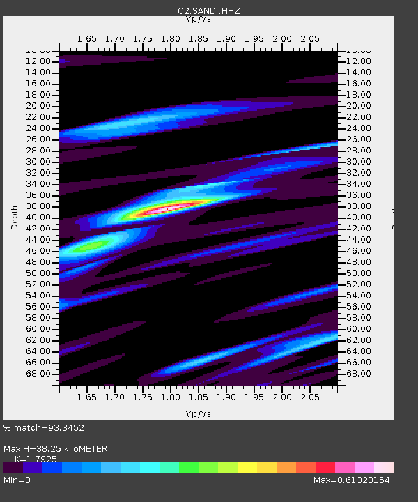
| Estimated Moho Depth: |
38.25 km |
| Estimated Crust Vp/Vs: |
1.79 |
| Assumed Crust Vp: |
6.483 km/s |
| Estimated Crust Vs: |
3.617 km/s |
| Estimated Crust Poisson's Ratio: |
0.27 |
|
| Radial Match: |
93.3452 % |
| Radial Bump: |
400 |
| Transverse Match: |
66.00976 % |
| Transverse Bump: |
400 |
| SOD ConfigId: |
29823551 |
| Insert Time: |
2022-12-18 20:12:27.911 +0000 |
| GWidth: |
2.5 |
| Max Bumps: |
400 |
| Tol: |
0.001 |
|

Signal To Noise
| Channel | StoN | STA | LTA |
| O2:SAND: :HHZ:20221204T19:36:31.034973Z | 4.6676354 | 9.562309E-7 | 2.048641E-7 |
| O2:SAND: :HHN:20221204T19:36:31.034973Z | 0.95280594 | 3.268876E-7 | 3.4307888E-7 |
| O2:SAND: :HHE:20221204T19:36:31.034973Z | 1.2379609 | 3.2176257E-7 | 2.5991335E-7 |
| Arrivals |
| Ps | 4.8 SECOND |
| PpPs | 16 SECOND |
| PsPs/PpSs | 21 SECOND |


