You are here: Home > Network List > O2 - Oklahoma Consolidated Temporary Seismic Networks Stations List
> Station SC17 Lindsey, Oklahoma, USA > Earthquake Result Viewer
SC17 Lindsey, Oklahoma, USA - Earthquake Result Viewer
| Earthquake location: |
Samoa Islands Region |
| Earthquake latitude/longitude: |
-15.7/-172.5 |
| Earthquake time(UTC): |
2022/12/04 (338) 19:24:27 GMT |
| Earthquake Depth: |
148 km |
| Earthquake Magnitude: |
6.9 Mi |
| Earthquake Catalog/Contributor: |
NEIC PDE/at |
|
| Network: |
O2 Oklahoma Consolidated Temporary Seismic Networks |
| Station: |
SC17 Lindsey, Oklahoma, USA |
| Lat/Lon: |
34.92 N/97.60 W |
| Elevation: |
1126 m |
|
| Distance: |
87.0 deg |
| Az: |
52.612 deg |
| Baz: |
248.626 deg |
| Ray Param: |
0.04333973 |
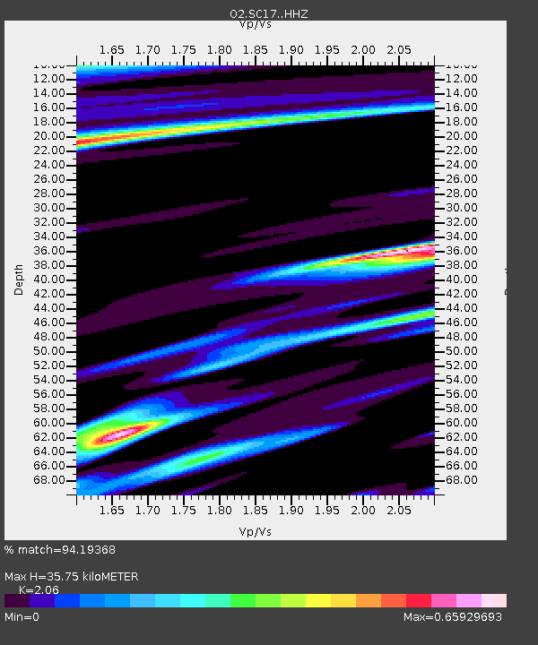
| Estimated Moho Depth: |
35.75 km |
| Estimated Crust Vp/Vs: |
2.06 |
| Assumed Crust Vp: |
6.426 km/s |
| Estimated Crust Vs: |
3.119 km/s |
| Estimated Crust Poisson's Ratio: |
0.35 |
|
| Radial Match: |
94.19368 % |
| Radial Bump: |
400 |
| Transverse Match: |
85.66216 % |
| Transverse Bump: |
400 |
| SOD ConfigId: |
29823551 |
| Insert Time: |
2022-12-18 20:12:54.681 +0000 |
| GWidth: |
2.5 |
| Max Bumps: |
400 |
| Tol: |
0.001 |
|

Signal To Noise
| Channel | StoN | STA | LTA |
| O2:SC17: :HHZ:20221204T19:36:24.205017Z | 2.4108586 | 8.3642E-7 | 3.4693863E-7 |
| O2:SC17: :HHN:20221204T19:36:24.205017Z | 0.36233005 | 1.938313E-7 | 5.3495785E-7 |
| O2:SC17: :HHE:20221204T19:36:24.205017Z | 1.0700655 | 5.3600604E-7 | 5.0090955E-7 |
| Arrivals |
| Ps | 6.0 SECOND |
| PpPs | 17 SECOND |
| PsPs/PpSs | 23 SECOND |


