You are here: Home > Network List > O2 - Oklahoma Consolidated Temporary Seismic Networks Stations List
> Station SHWN Shawnee, Oklahoma, USA > Earthquake Result Viewer
SHWN Shawnee, Oklahoma, USA - Earthquake Result Viewer
| Earthquake location: |
Samoa Islands Region |
| Earthquake latitude/longitude: |
-15.7/-172.5 |
| Earthquake time(UTC): |
2022/12/04 (338) 19:24:27 GMT |
| Earthquake Depth: |
148 km |
| Earthquake Magnitude: |
6.9 Mi |
| Earthquake Catalog/Contributor: |
NEIC PDE/at |
|
| Network: |
O2 Oklahoma Consolidated Temporary Seismic Networks |
| Station: |
SHWN Shawnee, Oklahoma, USA |
| Lat/Lon: |
35.34 N/97.02 W |
| Elevation: |
320 m |
|
| Distance: |
87.6 deg |
| Az: |
52.385 deg |
| Baz: |
248.945 deg |
| Ray Param: |
0.042908978 |
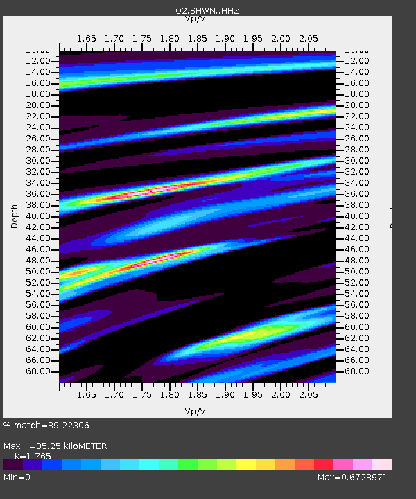
| Estimated Moho Depth: |
35.25 km |
| Estimated Crust Vp/Vs: |
1.76 |
| Assumed Crust Vp: |
6.426 km/s |
| Estimated Crust Vs: |
3.641 km/s |
| Estimated Crust Poisson's Ratio: |
0.26 |
|
| Radial Match: |
89.22306 % |
| Radial Bump: |
355 |
| Transverse Match: |
78.62528 % |
| Transverse Bump: |
400 |
| SOD ConfigId: |
29823551 |
| Insert Time: |
2022-12-18 20:13:01.527 +0000 |
| GWidth: |
2.5 |
| Max Bumps: |
400 |
| Tol: |
0.001 |
|

Signal To Noise
| Channel | StoN | STA | LTA |
| O2:SHWN: :HHZ:20221204T19:36:27.049988Z | 4.3769865 | 1.1555908E-6 | 2.6401517E-7 |
| O2:SHWN: :HHN:20221204T19:36:27.049988Z | 0.5830885 | 2.2163506E-7 | 3.8010538E-7 |
| O2:SHWN: :HHE:20221204T19:36:27.049988Z | 0.8379446 | 2.4078713E-7 | 2.8735448E-7 |
| Arrivals |
| Ps | 4.3 SECOND |
| PpPs | 15 SECOND |
| PsPs/PpSs | 19 SECOND |


