You are here: Home > Network List > O2 - Oklahoma Consolidated Temporary Seismic Networks Stations List
> Station UCTY Union City, Oklahoma, USA > Earthquake Result Viewer
UCTY Union City, Oklahoma, USA - Earthquake Result Viewer
| Earthquake location: |
Samoa Islands Region |
| Earthquake latitude/longitude: |
-15.7/-172.5 |
| Earthquake time(UTC): |
2022/12/04 (338) 19:24:27 GMT |
| Earthquake Depth: |
148 km |
| Earthquake Magnitude: |
6.9 Mi |
| Earthquake Catalog/Contributor: |
NEIC PDE/at |
|
| Network: |
O2 Oklahoma Consolidated Temporary Seismic Networks |
| Station: |
UCTY Union City, Oklahoma, USA |
| Lat/Lon: |
35.39 N/97.92 W |
| Elevation: |
1210 m |
|
| Distance: |
86.9 deg |
| Az: |
52.075 deg |
| Baz: |
248.415 deg |
| Ray Param: |
0.043385513 |
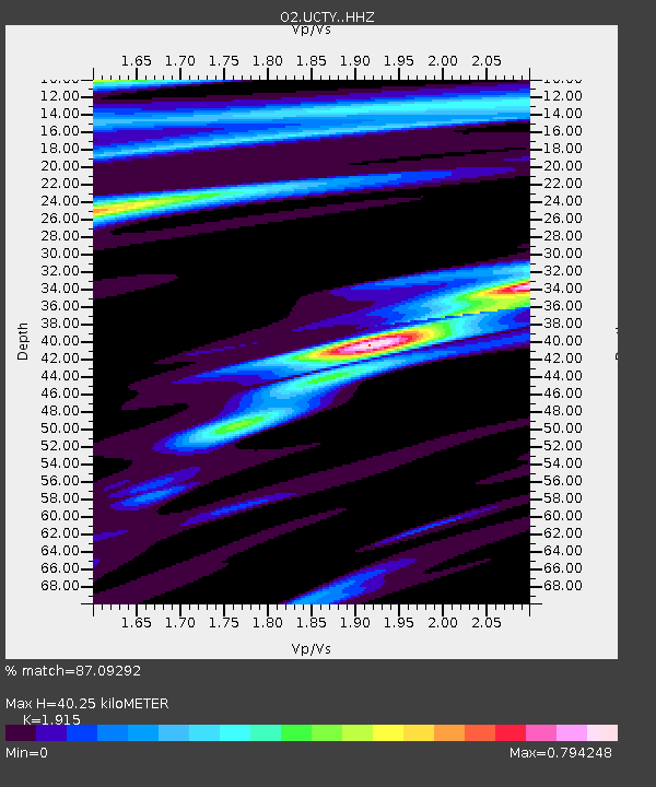
| Estimated Moho Depth: |
40.25 km |
| Estimated Crust Vp/Vs: |
1.91 |
| Assumed Crust Vp: |
6.426 km/s |
| Estimated Crust Vs: |
3.356 km/s |
| Estimated Crust Poisson's Ratio: |
0.31 |
|
| Radial Match: |
87.09292 % |
| Radial Bump: |
400 |
| Transverse Match: |
71.67941 % |
| Transverse Bump: |
400 |
| SOD ConfigId: |
29823551 |
| Insert Time: |
2022-12-18 20:13:09.429 +0000 |
| GWidth: |
2.5 |
| Max Bumps: |
400 |
| Tol: |
0.001 |
|

Signal To Noise
| Channel | StoN | STA | LTA |
| O2:UCTY: :HHZ:20221204T19:36:23.869995Z | 4.3669305 | 1.1361166E-6 | 2.6016366E-7 |
| O2:UCTY: :HHN:20221204T19:36:23.869995Z | 1.6476744 | 8.8939765E-7 | 5.397897E-7 |
| O2:UCTY: :HHE:20221204T19:36:23.869995Z | 1.4738792 | 1.366015E-6 | 9.268161E-7 |
| Arrivals |
| Ps | 5.9 SECOND |
| PpPs | 18 SECOND |
| PsPs/PpSs | 24 SECOND |


