You are here: Home > Network List > OK - Oklahoma Seismic Network Stations List
> Station DEOK Depew, Oklahoma, USA > Earthquake Result Viewer
DEOK Depew, Oklahoma, USA - Earthquake Result Viewer
| Earthquake location: |
Samoa Islands Region |
| Earthquake latitude/longitude: |
-15.7/-172.5 |
| Earthquake time(UTC): |
2022/12/04 (338) 19:24:27 GMT |
| Earthquake Depth: |
148 km |
| Earthquake Magnitude: |
6.9 Mi |
| Earthquake Catalog/Contributor: |
NEIC PDE/at |
|
| Network: |
OK Oklahoma Seismic Network |
| Station: |
DEOK Depew, Oklahoma, USA |
| Lat/Lon: |
35.84 N/96.50 W |
| Elevation: |
291 m |
|
| Distance: |
88.1 deg |
| Az: |
52.071 deg |
| Baz: |
249.237 deg |
| Ray Param: |
0.042481236 |
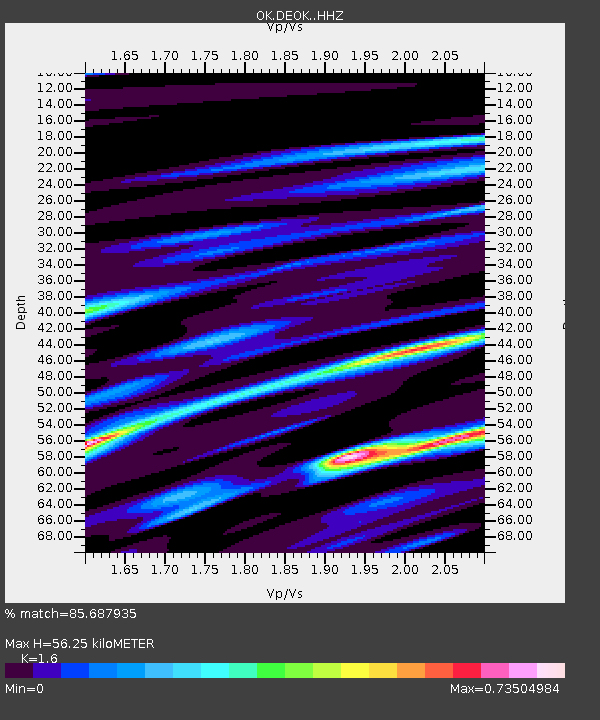
| Estimated Moho Depth: |
56.25 km |
| Estimated Crust Vp/Vs: |
1.60 |
| Assumed Crust Vp: |
6.426 km/s |
| Estimated Crust Vs: |
4.016 km/s |
| Estimated Crust Poisson's Ratio: |
0.18 |
|
| Radial Match: |
85.687935 % |
| Radial Bump: |
400 |
| Transverse Match: |
76.19647 % |
| Transverse Bump: |
400 |
| SOD ConfigId: |
29823551 |
| Insert Time: |
2022-12-18 20:13:19.542 +0000 |
| GWidth: |
2.5 |
| Max Bumps: |
400 |
| Tol: |
0.001 |
|

Signal To Noise
| Channel | StoN | STA | LTA |
| OK:DEOK: :HHZ:20221204T19:36:29.784973Z | 3.5439527 | 1.0950366E-6 | 3.0898738E-7 |
| OK:DEOK: :HHN:20221204T19:36:29.784973Z | 0.9358185 | 3.0161678E-7 | 3.2230264E-7 |
| OK:DEOK: :HHE:20221204T19:36:29.784973Z | 0.882307 | 3.3796778E-7 | 3.830501E-7 |
| Arrivals |
| Ps | 5.4 SECOND |
| PpPs | 22 SECOND |
| PsPs/PpSs | 28 SECOND |


