You are here: Home > Network List > RV - Regional Alberta Seismic Observatory for Earthquake Studies Network Stations List
> Station LGPLA Lodgepole, AB > Earthquake Result Viewer
LGPLA Lodgepole, AB - Earthquake Result Viewer
| Earthquake location: |
Samoa Islands Region |
| Earthquake latitude/longitude: |
-15.7/-172.5 |
| Earthquake time(UTC): |
2022/12/04 (338) 19:24:27 GMT |
| Earthquake Depth: |
148 km |
| Earthquake Magnitude: |
6.9 Mi |
| Earthquake Catalog/Contributor: |
NEIC PDE/at |
|
| Network: |
RV Regional Alberta Seismic Observatory for Earthquake Studies Network |
| Station: |
LGPLA Lodgepole, AB |
| Lat/Lon: |
53.11 N/115.36 W |
| Elevation: |
886 m |
|
| Distance: |
84.2 deg |
| Az: |
30.594 deg |
| Baz: |
234.411 deg |
| Ray Param: |
0.045289777 |
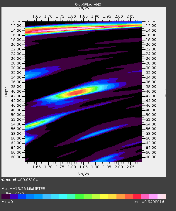
| Estimated Moho Depth: |
13.25 km |
| Estimated Crust Vp/Vs: |
1.78 |
| Assumed Crust Vp: |
6.426 km/s |
| Estimated Crust Vs: |
3.615 km/s |
| Estimated Crust Poisson's Ratio: |
0.27 |
|
| Radial Match: |
89.06104 % |
| Radial Bump: |
400 |
| Transverse Match: |
82.16861 % |
| Transverse Bump: |
400 |
| SOD ConfigId: |
29823551 |
| Insert Time: |
2022-12-18 20:15:55.376 +0000 |
| GWidth: |
2.5 |
| Max Bumps: |
400 |
| Tol: |
0.001 |
|

Signal To Noise
| Channel | StoN | STA | LTA |
| RV:LGPLA: :HHZ:20221204T19:36:10.789978Z | 7.4569163 | 2.8997918E-6 | 3.8887276E-7 |
| RV:LGPLA: :HHN:20221204T19:36:10.789978Z | 1.320212 | 5.157967E-7 | 3.9069235E-7 |
| RV:LGPLA: :HHE:20221204T19:36:10.789978Z | 2.2581797 | 1.3104863E-6 | 5.803286E-7 |
| Arrivals |
| Ps | 1.6 SECOND |
| PpPs | 5.6 SECOND |
| PsPs/PpSs | 7.2 SECOND |


