You are here: Home > Network List > SB - UC Santa Barbara Engineering Seismology Network () Stations List
> Station VAFB1 Globe Rd, Vandenberg AFB, CA, USA > Earthquake Result Viewer
VAFB1 Globe Rd, Vandenberg AFB, CA, USA - Earthquake Result Viewer
| Earthquake location: |
Samoa Islands Region |
| Earthquake latitude/longitude: |
-15.7/-172.5 |
| Earthquake time(UTC): |
2022/12/04 (338) 19:24:27 GMT |
| Earthquake Depth: |
148 km |
| Earthquake Magnitude: |
6.9 Mi |
| Earthquake Catalog/Contributor: |
NEIC PDE/at |
|
| Network: |
SB UC Santa Barbara Engineering Seismology Network () |
| Station: |
VAFB1 Globe Rd, Vandenberg AFB, CA, USA |
| Lat/Lon: |
34.86 N/120.60 W |
| Elevation: |
121 m |
|
| Distance: |
70.4 deg |
| Az: |
43.396 deg |
| Baz: |
233.578 deg |
| Ray Param: |
0.054628577 |
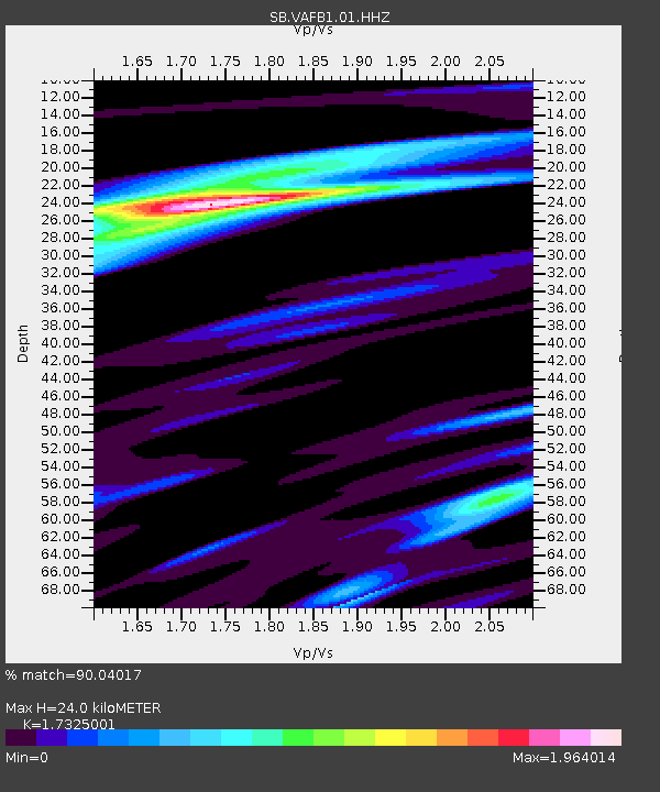
| Estimated Moho Depth: |
24.0 km |
| Estimated Crust Vp/Vs: |
1.73 |
| Assumed Crust Vp: |
6.183 km/s |
| Estimated Crust Vs: |
3.569 km/s |
| Estimated Crust Poisson's Ratio: |
0.25 |
|
| Radial Match: |
90.04017 % |
| Radial Bump: |
372 |
| Transverse Match: |
71.909424 % |
| Transverse Bump: |
400 |
| SOD ConfigId: |
29823551 |
| Insert Time: |
2022-12-18 20:17:27.125 +0000 |
| GWidth: |
2.5 |
| Max Bumps: |
400 |
| Tol: |
0.001 |
|

Signal To Noise
| Channel | StoN | STA | LTA |
| SB:VAFB1:01:HHZ:20221204T19:34:53.984985Z | 3.1258898 | 2.8453828E-6 | 9.102634E-7 |
| SB:VAFB1:01:HHN:20221204T19:34:53.984985Z | 0.99790496 | 1.1716725E-6 | 1.1741323E-6 |
| SB:VAFB1:01:HHE:20221204T19:34:53.984985Z | 1.2235802 | 8.8448184E-7 | 7.2286383E-7 |
| Arrivals |
| Ps | 2.9 SECOND |
| PpPs | 10 SECOND |
| PsPs/PpSs | 13 SECOND |


