You are here: Home > Network List > SB - UC Santa Barbara Engineering Seismology Network () Stations List
> Station VAFB2 Taft Rd, Vandenberg AFB, CA, USA > Earthquake Result Viewer
VAFB2 Taft Rd, Vandenberg AFB, CA, USA - Earthquake Result Viewer
| Earthquake location: |
Samoa Islands Region |
| Earthquake latitude/longitude: |
-15.7/-172.5 |
| Earthquake time(UTC): |
2022/12/04 (338) 19:24:27 GMT |
| Earthquake Depth: |
148 km |
| Earthquake Magnitude: |
6.9 Mi |
| Earthquake Catalog/Contributor: |
NEIC PDE/at |
|
| Network: |
SB UC Santa Barbara Engineering Seismology Network () |
| Station: |
VAFB2 Taft Rd, Vandenberg AFB, CA, USA |
| Lat/Lon: |
34.84 N/120.58 W |
| Elevation: |
91 m |
|
| Distance: |
70.4 deg |
| Az: |
43.415 deg |
| Baz: |
233.593 deg |
| Ray Param: |
0.05462682 |
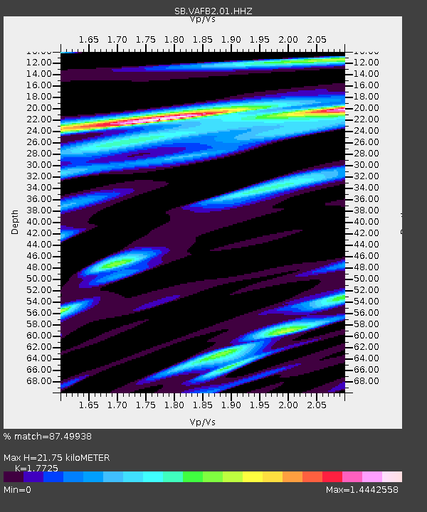
| Estimated Moho Depth: |
21.75 km |
| Estimated Crust Vp/Vs: |
1.77 |
| Assumed Crust Vp: |
6.183 km/s |
| Estimated Crust Vs: |
3.488 km/s |
| Estimated Crust Poisson's Ratio: |
0.27 |
|
| Radial Match: |
87.49938 % |
| Radial Bump: |
400 |
| Transverse Match: |
77.9594 % |
| Transverse Bump: |
400 |
| SOD ConfigId: |
29823551 |
| Insert Time: |
2022-12-18 20:17:27.517 +0000 |
| GWidth: |
2.5 |
| Max Bumps: |
400 |
| Tol: |
0.001 |
|

Signal To Noise
| Channel | StoN | STA | LTA |
| SB:VAFB2:01:HHZ:20221204T19:34:54.000Z | 3.9932737 | 3.8167123E-6 | 9.557853E-7 |
| SB:VAFB2:01:HHN:20221204T19:34:54.000Z | 1.7239851 | 1.3631275E-6 | 7.90684E-7 |
| SB:VAFB2:01:HHE:20221204T19:34:54.000Z | 1.5721835 | 1.3639881E-6 | 8.675757E-7 |
| Arrivals |
| Ps | 2.8 SECOND |
| PpPs | 9.4 SECOND |
| PsPs/PpSs | 12 SECOND |


