You are here: Home > Network List > SN - Southern Great Basin Network Stations List
> Station HEL Hell's Gate, California w84 > Earthquake Result Viewer
HEL Hell's Gate, California w84 - Earthquake Result Viewer
| Earthquake location: |
Samoa Islands Region |
| Earthquake latitude/longitude: |
-15.7/-172.5 |
| Earthquake time(UTC): |
2022/12/04 (338) 19:24:27 GMT |
| Earthquake Depth: |
148 km |
| Earthquake Magnitude: |
6.9 Mi |
| Earthquake Catalog/Contributor: |
NEIC PDE/at |
|
| Network: |
SN Southern Great Basin Network |
| Station: |
HEL Hell's Gate, California w84 |
| Lat/Lon: |
36.72 N/116.98 W |
| Elevation: |
747 m |
|
| Distance: |
73.9 deg |
| Az: |
43.59 deg |
| Baz: |
235.747 deg |
| Ray Param: |
0.052350834 |
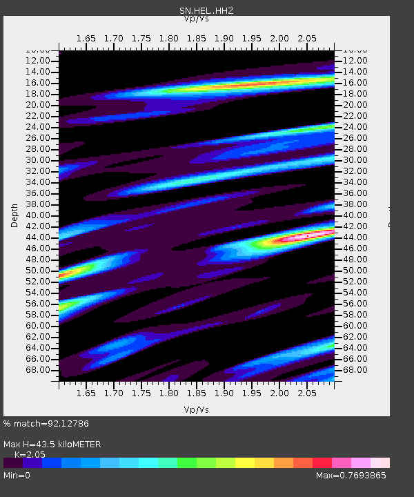
| Estimated Moho Depth: |
43.5 km |
| Estimated Crust Vp/Vs: |
2.05 |
| Assumed Crust Vp: |
6.279 km/s |
| Estimated Crust Vs: |
3.063 km/s |
| Estimated Crust Poisson's Ratio: |
0.34 |
|
| Radial Match: |
92.12786 % |
| Radial Bump: |
400 |
| Transverse Match: |
87.63151 % |
| Transverse Bump: |
400 |
| SOD ConfigId: |
29823551 |
| Insert Time: |
2022-12-18 20:17:36.300 +0000 |
| GWidth: |
2.5 |
| Max Bumps: |
400 |
| Tol: |
0.001 |
|

Signal To Noise
| Channel | StoN | STA | LTA |
| SN:HEL: :HHZ:20221204T19:35:14.607971Z | 5.1897907 | 2.157294E-6 | 4.156803E-7 |
| SN:HEL: :HHN:20221204T19:35:14.607971Z | 1.7419767 | 7.6310727E-7 | 4.3806972E-7 |
| SN:HEL: :HHE:20221204T19:35:14.607971Z | 2.9568193 | 7.073719E-7 | 2.3923408E-7 |
| Arrivals |
| Ps | 7.5 SECOND |
| PpPs | 21 SECOND |
| PsPs/PpSs | 28 SECOND |


