You are here: Home > Network List > TM - Thai Seismic Monitoring Network Stations List
> Station SKLT Mueang, Songkhla > Earthquake Result Viewer
SKLT Mueang, Songkhla - Earthquake Result Viewer
| Earthquake location: |
Samoa Islands Region |
| Earthquake latitude/longitude: |
-15.7/-172.5 |
| Earthquake time(UTC): |
2022/12/04 (338) 19:24:27 GMT |
| Earthquake Depth: |
148 km |
| Earthquake Magnitude: |
6.9 Mi |
| Earthquake Catalog/Contributor: |
NEIC PDE/at |
|
| Network: |
TM Thai Seismic Monitoring Network |
| Station: |
SKLT Mueang, Songkhla |
| Lat/Lon: |
7.18 N/100.62 E |
| Elevation: |
11 m |
|
| Distance: |
88.9 deg |
| Az: |
277.703 deg |
| Baz: |
105.866 deg |
| Ray Param: |
0.04190165 |
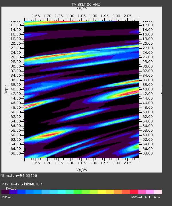
| Estimated Moho Depth: |
47.5 km |
| Estimated Crust Vp/Vs: |
1.60 |
| Assumed Crust Vp: |
6.468 km/s |
| Estimated Crust Vs: |
4.042 km/s |
| Estimated Crust Poisson's Ratio: |
0.18 |
|
| Radial Match: |
94.63496 % |
| Radial Bump: |
256 |
| Transverse Match: |
85.94854 % |
| Transverse Bump: |
400 |
| SOD ConfigId: |
29823551 |
| Insert Time: |
2022-12-18 20:18:35.202 +0000 |
| GWidth: |
2.5 |
| Max Bumps: |
400 |
| Tol: |
0.001 |
|

Signal To Noise
| Channel | StoN | STA | LTA |
| TM:SKLT:00:HHZ:20221204T19:36:33.530029Z | 3.0584307 | 4.8642585E-7 | 1.5904426E-7 |
| TM:SKLT:00:HHN:20221204T19:36:33.530029Z | 1.0112891 | 1.5748877E-7 | 1.557307E-7 |
| TM:SKLT:00:HHE:20221204T19:36:33.530029Z | 1.1395459 | 2.0854374E-7 | 1.83006E-7 |
| Arrivals |
| Ps | 4.5 SECOND |
| PpPs | 19 SECOND |
| PsPs/PpSs | 23 SECOND |


