You are here: Home > Network List > UO - University of Oregon Regional Network Stations List
> Station VITI Monroe, OR, USA > Earthquake Result Viewer
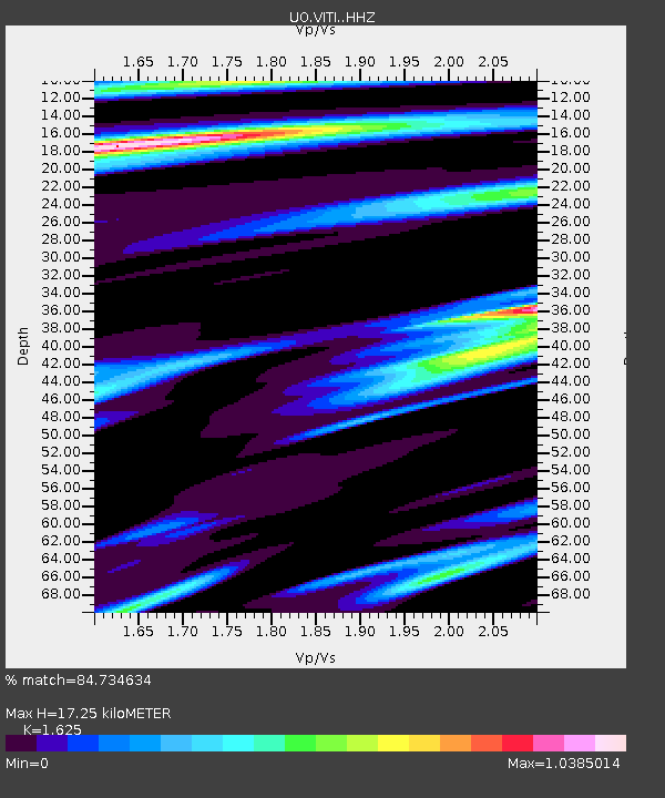
VITI Monroe, OR, USA - Earthquake Result Viewer
| Earthquake location: |
Samoa Islands Region |
| Earthquake latitude/longitude: |
-15.7/-172.5 |
| Earthquake time(UTC): |
2022/12/04 (338) 19:24:27 GMT |
| Earthquake Depth: |
148 km |
| Earthquake Magnitude: |
6.9 Mi |
| Earthquake Catalog/Contributor: |
NEIC PDE/at |
|
| Network: |
UO University of Oregon Regional Network |
| Station: |
VITI Monroe, OR, USA |
| Lat/Lon: |
44.28 N/123.32 W |
| Elevation: |
258 m |
|
| Distance: |
74.6 deg |
| Az: |
34.315 deg |
| Baz: |
229.109 deg |
| Ray Param: |
0.051838484 |
| Estimated Moho Depth: |
17.25 km |
| Estimated Crust Vp/Vs: |
1.62 |
| Assumed Crust Vp: |
6.566 km/s |
| Estimated Crust Vs: |
4.041 km/s |
| Estimated Crust Poisson's Ratio: |
0.20 |
|
| Radial Match: |
84.734634 % |
| Radial Bump: |
400 |
| Transverse Match: |
75.78404 % |
| Transverse Bump: |
400 |
| SOD ConfigId: |
29823551 |
| Insert Time: |
2022-12-18 20:21:55.603 +0000 |
| GWidth: |
2.5 |
| Max Bumps: |
400 |
| Tol: |
0.001 |
|

Signal To Noise
| Channel | StoN | STA | LTA |
| UO:VITI: :HHZ:20221204T19:35:19.02002Z | 8.028578 | 3.6084446E-6 | 4.4945003E-7 |
| UO:VITI: :HHN:20221204T19:35:19.02002Z | 1.2185614 | 5.9115706E-7 | 4.8512703E-7 |
| UO:VITI: :HHE:20221204T19:35:19.02002Z | 1.4008268 | 8.4300484E-7 | 6.0179093E-7 |
| Arrivals |
| Ps | 1.7 SECOND |
| PpPs | 6.6 SECOND |
| PsPs/PpSs | 8.3 SECOND |


