You are here: Home > Network List > US - United States National Seismic Network Stations List
> Station RLMT Red Lodge, Montana, USA > Earthquake Result Viewer
RLMT Red Lodge, Montana, USA - Earthquake Result Viewer
| Earthquake location: |
Samoa Islands Region |
| Earthquake latitude/longitude: |
-15.7/-172.5 |
| Earthquake time(UTC): |
2022/12/04 (338) 19:24:27 GMT |
| Earthquake Depth: |
148 km |
| Earthquake Magnitude: |
6.9 Mi |
| Earthquake Catalog/Contributor: |
NEIC PDE/at |
|
| Network: |
US United States National Seismic Network |
| Station: |
RLMT Red Lodge, Montana, USA |
| Lat/Lon: |
45.12 N/109.27 W |
| Elevation: |
2086 m |
|
| Distance: |
83.3 deg |
| Az: |
39.531 deg |
| Baz: |
239.988 deg |
| Ray Param: |
0.0459644 |
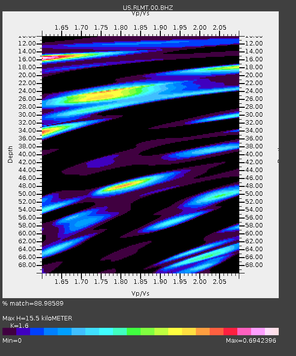
| Estimated Moho Depth: |
15.5 km |
| Estimated Crust Vp/Vs: |
1.60 |
| Assumed Crust Vp: |
6.242 km/s |
| Estimated Crust Vs: |
3.901 km/s |
| Estimated Crust Poisson's Ratio: |
0.18 |
|
| Radial Match: |
88.98589 % |
| Radial Bump: |
400 |
| Transverse Match: |
89.353836 % |
| Transverse Bump: |
400 |
| SOD ConfigId: |
29823551 |
| Insert Time: |
2022-12-18 20:22:54.925 +0000 |
| GWidth: |
2.5 |
| Max Bumps: |
400 |
| Tol: |
0.001 |
|

Signal To Noise
| Channel | StoN | STA | LTA |
| US:RLMT:00:BHZ:20221204T19:36:05.898987Z | 6.776041 | 1.6962504E-6 | 2.503306E-7 |
| US:RLMT:00:BH1:20221204T19:36:05.898987Z | 1.9184301 | 4.1487718E-7 | 2.1625868E-7 |
| US:RLMT:00:BH2:20221204T19:36:05.898987Z | 3.304573 | 5.186189E-7 | 1.5693976E-7 |
| Arrivals |
| Ps | 1.5 SECOND |
| PpPs | 6.3 SECOND |
| PsPs/PpSs | 7.8 SECOND |


