You are here: Home > Network List > UU - University of Utah Regional Network Stations List
> Station CCUT Cedar City, UT, USA > Earthquake Result Viewer
CCUT Cedar City, UT, USA - Earthquake Result Viewer
| Earthquake location: |
Samoa Islands Region |
| Earthquake latitude/longitude: |
-15.7/-172.5 |
| Earthquake time(UTC): |
2022/12/04 (338) 19:24:27 GMT |
| Earthquake Depth: |
148 km |
| Earthquake Magnitude: |
6.9 Mi |
| Earthquake Catalog/Contributor: |
NEIC PDE/at |
|
| Network: |
UU University of Utah Regional Network |
| Station: |
CCUT Cedar City, UT, USA |
| Lat/Lon: |
37.55 N/113.36 W |
| Elevation: |
2127 m |
|
| Distance: |
76.7 deg |
| Az: |
44.503 deg |
| Baz: |
238.152 deg |
| Ray Param: |
0.050434474 |
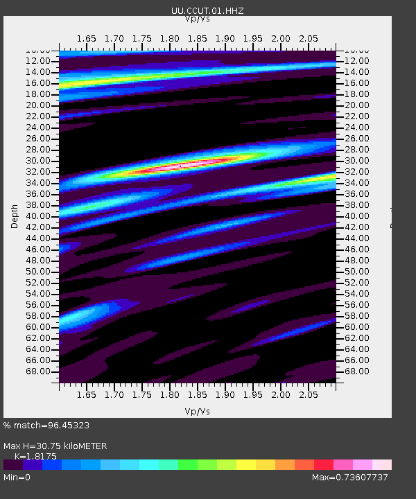
| Estimated Moho Depth: |
30.75 km |
| Estimated Crust Vp/Vs: |
1.82 |
| Assumed Crust Vp: |
6.194 km/s |
| Estimated Crust Vs: |
3.408 km/s |
| Estimated Crust Poisson's Ratio: |
0.28 |
|
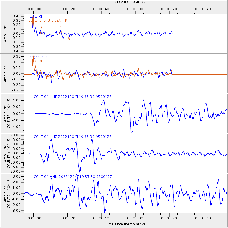
| Radial Match: |
96.45323 % |
| Radial Bump: |
400 |
| Transverse Match: |
86.12345 % |
| Transverse Bump: |
400 |
| SOD ConfigId: |
29823551 |
| Insert Time: |
2022-12-18 20:23:09.806 +0000 |
| GWidth: |
2.5 |
| Max Bumps: |
400 |
| Tol: |
0.001 |
|
Signal To Noise
| Channel | StoN | STA | LTA |
| UU:CCUT:01:HHZ:20221204T19:35:30.950012Z | 2.674985 | 5.628502E-7 | 2.1041245E-7 |
| UU:CCUT:01:HHN:20221204T19:35:30.950012Z | 0.5559924 | 1.3798156E-7 | 2.4817166E-7 |
| UU:CCUT:01:HHE:20221204T19:35:30.950012Z | 2.0798209 | 2.4975964E-7 | 1.200871E-7 |
| Arrivals |
| Ps | 4.2 SECOND |
| PpPs | 14 SECOND |
| PsPs/PpSs | 18 SECOND |


