You are here: Home > Network List > UU - University of Utah Regional Network Stations List
> Station FSB3 FORGE surface borehole 3, UT, USA > Earthquake Result Viewer
FSB3 FORGE surface borehole 3, UT, USA - Earthquake Result Viewer
| Earthquake location: |
Samoa Islands Region |
| Earthquake latitude/longitude: |
-15.7/-172.5 |
| Earthquake time(UTC): |
2022/12/04 (338) 19:24:27 GMT |
| Earthquake Depth: |
148 km |
| Earthquake Magnitude: |
6.9 Mi |
| Earthquake Catalog/Contributor: |
NEIC PDE/at |
|
| Network: |
UU University of Utah Regional Network |
| Station: |
FSB3 FORGE surface borehole 3, UT, USA |
| Lat/Lon: |
38.51 N/112.88 W |
| Elevation: |
1701 m |
|
| Distance: |
77.6 deg |
| Az: |
43.871 deg |
| Baz: |
238.307 deg |
| Ray Param: |
0.04988383 |
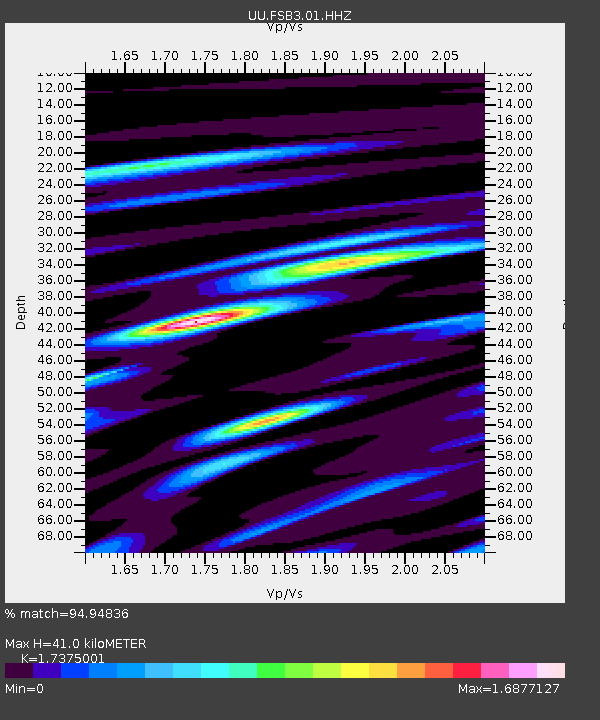
| Estimated Moho Depth: |
41.0 km |
| Estimated Crust Vp/Vs: |
1.74 |
| Assumed Crust Vp: |
6.276 km/s |
| Estimated Crust Vs: |
3.612 km/s |
| Estimated Crust Poisson's Ratio: |
0.25 |
|
| Radial Match: |
94.94836 % |
| Radial Bump: |
400 |
| Transverse Match: |
83.66407 % |
| Transverse Bump: |
400 |
| SOD ConfigId: |
29823551 |
| Insert Time: |
2022-12-18 20:23:26.454 +0000 |
| GWidth: |
2.5 |
| Max Bumps: |
400 |
| Tol: |
0.001 |
|

Signal To Noise
| Channel | StoN | STA | LTA |
| UU:FSB3:01:HHZ:20221204T19:35:35.559998Z | 3.1911206 | 8.7391743E-7 | 2.738591E-7 |
| UU:FSB3:01:HH1:20221204T19:35:35.559998Z | 1.5764898 | 4.78036E-7 | 3.032281E-7 |
| UU:FSB3:01:HH2:20221204T19:35:35.559998Z | 1.0968616 | 2.6560832E-7 | 2.42153E-7 |
| Arrivals |
| Ps | 5.0 SECOND |
| PpPs | 17 SECOND |
| PsPs/PpSs | 22 SECOND |


