You are here: Home > Network List > UU - University of Utah Regional Network Stations List
> Station TCU Toone Canyon, UT, USA > Earthquake Result Viewer
TCU Toone Canyon, UT, USA - Earthquake Result Viewer
| Earthquake location: |
Samoa Islands Region |
| Earthquake latitude/longitude: |
-15.7/-172.5 |
| Earthquake time(UTC): |
2022/12/04 (338) 19:24:27 GMT |
| Earthquake Depth: |
148 km |
| Earthquake Magnitude: |
6.9 Mi |
| Earthquake Catalog/Contributor: |
NEIC PDE/at |
|
| Network: |
UU University of Utah Regional Network |
| Station: |
TCU Toone Canyon, UT, USA |
| Lat/Lon: |
41.12 N/111.41 W |
| Elevation: |
2269 m |
|
| Distance: |
79.9 deg |
| Az: |
42.21 deg |
| Baz: |
238.921 deg |
| Ray Param: |
0.0483053 |
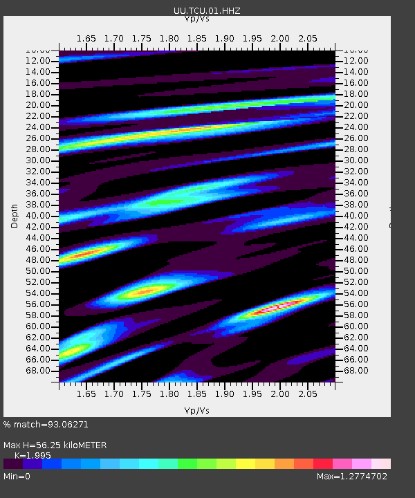
| Estimated Moho Depth: |
56.25 km |
| Estimated Crust Vp/Vs: |
2.00 |
| Assumed Crust Vp: |
6.155 km/s |
| Estimated Crust Vs: |
3.085 km/s |
| Estimated Crust Poisson's Ratio: |
0.33 |
|
| Radial Match: |
93.06271 % |
| Radial Bump: |
400 |
| Transverse Match: |
87.322464 % |
| Transverse Bump: |
400 |
| SOD ConfigId: |
29823551 |
| Insert Time: |
2022-12-18 20:23:42.266 +0000 |
| GWidth: |
2.5 |
| Max Bumps: |
400 |
| Tol: |
0.001 |
|

Signal To Noise
| Channel | StoN | STA | LTA |
| UU:TCU:01:HHZ:20221204T19:35:48.210022Z | 6.209217 | 2.2413387E-6 | 3.6096964E-7 |
| UU:TCU:01:HHN:20221204T19:35:48.210022Z | 1.4245266 | 3.520758E-7 | 2.4715285E-7 |
| UU:TCU:01:HHE:20221204T19:35:48.210022Z | 1.15038 | 5.402012E-7 | 4.6958502E-7 |
| Arrivals |
| Ps | 9.3 SECOND |
| PpPs | 27 SECOND |
| PsPs/PpSs | 36 SECOND |


