You are here: Home > Network List > UW - Pacific Northwest Regional Seismic Network Stations List
> Station CORE Aberdeen, WA, USA > Earthquake Result Viewer
CORE Aberdeen, WA, USA - Earthquake Result Viewer
| Earthquake location: |
Samoa Islands Region |
| Earthquake latitude/longitude: |
-15.7/-172.5 |
| Earthquake time(UTC): |
2022/12/04 (338) 19:24:27 GMT |
| Earthquake Depth: |
148 km |
| Earthquake Magnitude: |
6.9 Mi |
| Earthquake Catalog/Contributor: |
NEIC PDE/at |
|
| Network: |
UW Pacific Northwest Regional Seismic Network |
| Station: |
CORE Aberdeen, WA, USA |
| Lat/Lon: |
46.93 N/123.91 W |
| Elevation: |
46 m |
|
| Distance: |
76.1 deg |
| Az: |
31.979 deg |
| Baz: |
228.094 deg |
| Ray Param: |
0.050885953 |
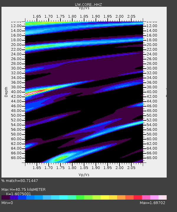
| Estimated Moho Depth: |
40.75 km |
| Estimated Crust Vp/Vs: |
1.61 |
| Assumed Crust Vp: |
6.566 km/s |
| Estimated Crust Vs: |
4.085 km/s |
| Estimated Crust Poisson's Ratio: |
0.18 |
|
| Radial Match: |
80.71447 % |
| Radial Bump: |
400 |
| Transverse Match: |
81.419846 % |
| Transverse Bump: |
400 |
| SOD ConfigId: |
29823551 |
| Insert Time: |
2022-12-18 20:24:20.860 +0000 |
| GWidth: |
2.5 |
| Max Bumps: |
400 |
| Tol: |
0.001 |
|

Signal To Noise
| Channel | StoN | STA | LTA |
| UW:CORE: :HHZ:20221204T19:35:27.190002Z | 5.775624 | 4.800218E-6 | 8.311168E-7 |
| UW:CORE: :HHN:20221204T19:35:27.190002Z | 1.0091853 | 1.8106483E-6 | 1.7941684E-6 |
| UW:CORE: :HHE:20221204T19:35:27.190002Z | 0.83675766 | 1.4497714E-6 | 1.732606E-6 |
| Arrivals |
| Ps | 3.9 SECOND |
| PpPs | 16 SECOND |
| PsPs/PpSs | 20 SECOND |


