You are here: Home > Network List > UW - Pacific Northwest Regional Seismic Network Stations List
> Station HDW Hoodsport, WA, USA > Earthquake Result Viewer
HDW Hoodsport, WA, USA - Earthquake Result Viewer
| Earthquake location: |
Samoa Islands Region |
| Earthquake latitude/longitude: |
-15.7/-172.5 |
| Earthquake time(UTC): |
2022/12/04 (338) 19:24:27 GMT |
| Earthquake Depth: |
148 km |
| Earthquake Magnitude: |
6.9 Mi |
| Earthquake Catalog/Contributor: |
NEIC PDE/at |
|
| Network: |
UW Pacific Northwest Regional Seismic Network |
| Station: |
HDW Hoodsport, WA, USA |
| Lat/Lon: |
47.65 N/123.06 W |
| Elevation: |
1006 m |
|
| Distance: |
77.0 deg |
| Az: |
31.822 deg |
| Baz: |
228.686 deg |
| Ray Param: |
0.050275255 |
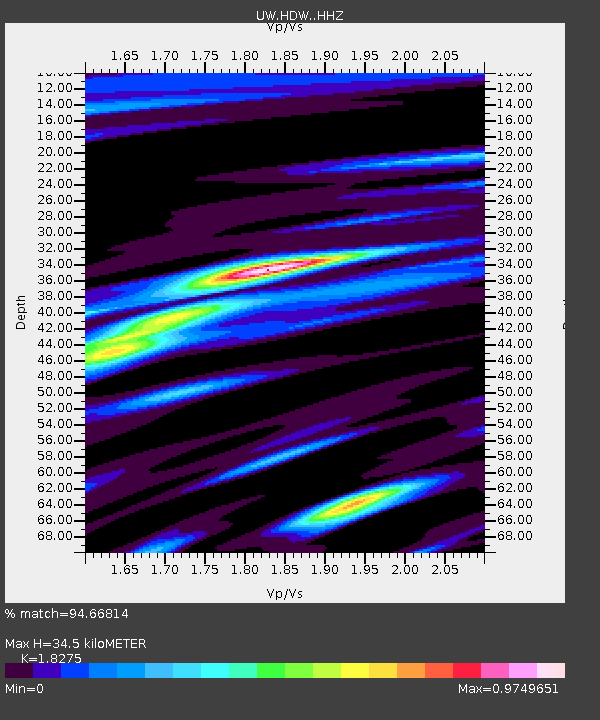
| Estimated Moho Depth: |
34.5 km |
| Estimated Crust Vp/Vs: |
1.83 |
| Assumed Crust Vp: |
6.566 km/s |
| Estimated Crust Vs: |
3.593 km/s |
| Estimated Crust Poisson's Ratio: |
0.29 |
|
| Radial Match: |
94.66814 % |
| Radial Bump: |
400 |
| Transverse Match: |
95.125694 % |
| Transverse Bump: |
378 |
| SOD ConfigId: |
29823551 |
| Insert Time: |
2022-12-18 20:25:13.405 +0000 |
| GWidth: |
2.5 |
| Max Bumps: |
400 |
| Tol: |
0.001 |
|

Signal To Noise
| Channel | StoN | STA | LTA |
| UW:HDW: :HHZ:20221204T19:35:32.330017Z | 11.16741 | 3.1043298E-6 | 2.7798117E-7 |
| UW:HDW: :HHN:20221204T19:35:32.330017Z | 2.4387512 | 8.4639566E-7 | 3.470611E-7 |
| UW:HDW: :HHE:20221204T19:35:32.330017Z | 2.351243 | 5.2732014E-7 | 2.2427292E-7 |
| Arrivals |
| Ps | 4.5 SECOND |
| PpPs | 14 SECOND |
| PsPs/PpSs | 19 SECOND |


