You are here: Home > Network List > UW - Pacific Northwest Regional Seismic Network Stations List
> Station MOX Moxee City, WA, USA (was ISC code MXC) > Earthquake Result Viewer
MOX Moxee City, WA, USA (was ISC code MXC) - Earthquake Result Viewer
| Earthquake location: |
Samoa Islands Region |
| Earthquake latitude/longitude: |
-15.7/-172.5 |
| Earthquake time(UTC): |
2022/12/04 (338) 19:24:27 GMT |
| Earthquake Depth: |
148 km |
| Earthquake Magnitude: |
6.9 Mi |
| Earthquake Catalog/Contributor: |
NEIC PDE/at |
|
| Network: |
UW Pacific Northwest Regional Seismic Network |
| Station: |
MOX Moxee City, WA, USA (was ISC code MXC) |
| Lat/Lon: |
46.58 N/120.30 W |
| Elevation: |
501 m |
|
| Distance: |
77.7 deg |
| Az: |
33.904 deg |
| Baz: |
231.155 deg |
| Ray Param: |
0.04976819 |
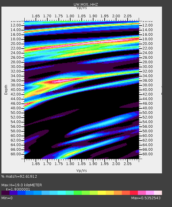
| Estimated Moho Depth: |
19.0 km |
| Estimated Crust Vp/Vs: |
1.93 |
| Assumed Crust Vp: |
6.597 km/s |
| Estimated Crust Vs: |
3.418 km/s |
| Estimated Crust Poisson's Ratio: |
0.32 |
|
| Radial Match: |
92.61912 % |
| Radial Bump: |
280 |
| Transverse Match: |
85.83974 % |
| Transverse Bump: |
400 |
| SOD ConfigId: |
29823551 |
| Insert Time: |
2022-12-18 20:26:14.954 +0000 |
| GWidth: |
2.5 |
| Max Bumps: |
400 |
| Tol: |
0.001 |
|

Signal To Noise
| Channel | StoN | STA | LTA |
| UW:MOX: :HHZ:20221204T19:35:36.48999Z | 16.490803 | 3.7711445E-6 | 2.2868169E-7 |
| UW:MOX: :HHN:20221204T19:35:36.48999Z | 3.615547 | 7.4101274E-7 | 2.0495176E-7 |
| UW:MOX: :HHE:20221204T19:35:36.48999Z | 4.3491044 | 7.8823155E-7 | 1.8123995E-7 |
| Arrivals |
| Ps | 2.8 SECOND |
| PpPs | 8.2 SECOND |
| PsPs/PpSs | 11 SECOND |


