You are here: Home > Network List > CB - China National Seismic Network Stations List
> Station GOM Geermu,Qinghai Province > Earthquake Result Viewer
GOM Geermu,Qinghai Province - Earthquake Result Viewer
| Earthquake location: |
W. Caroline Islands, Micronesia |
| Earthquake latitude/longitude: |
10.0/140.1 |
| Earthquake time(UTC): |
2017/12/08 (342) 09:51:10 GMT |
| Earthquake Depth: |
20 km |
| Earthquake Magnitude: |
6.4 Mww |
| Earthquake Catalog/Contributor: |
NEIC PDE/us |
|
| Network: |
CB China National Seismic Network |
| Station: |
GOM Geermu,Qinghai Province |
| Lat/Lon: |
36.20 N/94.81 E |
| Elevation: |
3121 m |
|
| Distance: |
48.6 deg |
| Az: |
309.905 deg |
| Baz: |
110.912 deg |
| Ray Param: |
0.06924985 |
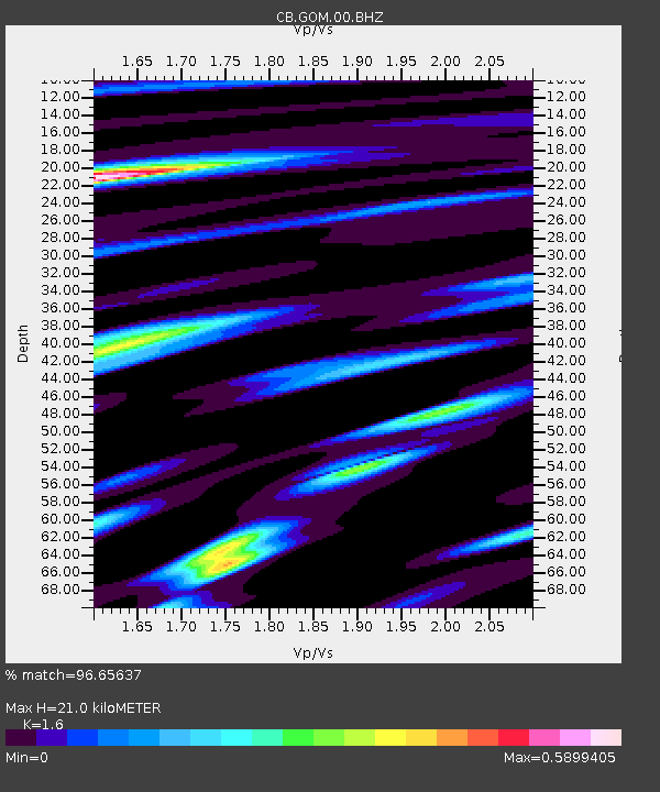
| Estimated Moho Depth: |
21.0 km |
| Estimated Crust Vp/Vs: |
1.60 |
| Assumed Crust Vp: |
6.385 km/s |
| Estimated Crust Vs: |
3.991 km/s |
| Estimated Crust Poisson's Ratio: |
0.18 |
|
| Radial Match: |
96.65637 % |
| Radial Bump: |
382 |
| Transverse Match: |
88.64336 % |
| Transverse Bump: |
400 |
| SOD ConfigId: |
2973751 |
| Insert Time: |
2018-10-09 03:46:41.937 +0000 |
| GWidth: |
2.5 |
| Max Bumps: |
400 |
| Tol: |
0.001 |
|

Signal To Noise
| Channel | StoN | STA | LTA |
| CB:GOM:00:BHZ:20171208T09:59:21.250012Z | 12.82881 | 6.871482E-7 | 5.3562896E-8 |
| CB:GOM:00:BHN:20171208T09:59:21.250012Z | 2.30242 | 1.2161007E-7 | 5.2818372E-8 |
| CB:GOM:00:BHE:20171208T09:59:21.250012Z | 5.3506584 | 2.5983027E-7 | 4.856043E-8 |
| Arrivals |
| Ps | 2.1 SECOND |
| PpPs | 8.0 SECOND |
| PsPs/PpSs | 10 SECOND |


