You are here: Home > Network List > TA - USArray Transportable Network (new EarthScope stations) Stations List
> Station Z25A Roswell, NM, USA > Earthquake Result Viewer
Z25A Roswell, NM, USA - Earthquake Result Viewer
| Earthquake location: |
Near Coast Of Central Chile |
| Earthquake latitude/longitude: |
-36.7/-73.4 |
| Earthquake time(UTC): |
2010/03/05 (064) 11:47:06 GMT |
| Earthquake Depth: |
18 km |
| Earthquake Magnitude: |
6.1 MB, 6.7 MS, 6.6 MW, 6.6 MW |
| Earthquake Catalog/Contributor: |
WHDF/NEIC |
|
| Network: |
TA USArray Transportable Network (new EarthScope stations) |
| Station: |
Z25A Roswell, NM, USA |
| Lat/Lon: |
33.28 N/104.72 W |
| Elevation: |
1233 m |
|
| Distance: |
75.5 deg |
| Az: |
333.25 deg |
| Baz: |
154.404 deg |
| Ray Param: |
0.05161799 |
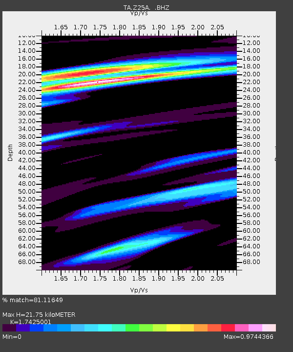
| Estimated Moho Depth: |
21.75 km |
| Estimated Crust Vp/Vs: |
1.74 |
| Assumed Crust Vp: |
6.232 km/s |
| Estimated Crust Vs: |
3.576 km/s |
| Estimated Crust Poisson's Ratio: |
0.25 |
|
| Radial Match: |
81.11649 % |
| Radial Bump: |
392 |
| Transverse Match: |
62.684647 % |
| Transverse Bump: |
400 |
| SOD ConfigId: |
299721 |
| Insert Time: |
2010-04-26 17:05:26.350 +0000 |
| GWidth: |
2.5 |
| Max Bumps: |
400 |
| Tol: |
0.001 |
|
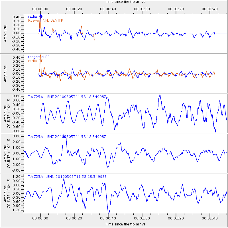
Signal To Noise
| Channel | StoN | STA | LTA |
| TA:Z25A: :BHZ:20100305T11:58:18.54998Z | 2.8448977 | 7.2061994E-7 | 2.5330257E-7 |
| TA:Z25A: :BHN:20100305T11:58:18.54998Z | 0.92924815 | 2.2633205E-7 | 2.435647E-7 |
| TA:Z25A: :BHE:20100305T11:58:18.54998Z | 0.9769435 | 2.736727E-7 | 2.8013156E-7 |
| Arrivals |
| Ps | 2.7 SECOND |
| PpPs | 9.3 SECOND |
| PsPs/PpSs | 12 SECOND |


