You are here: Home > Network List > UW - Pacific Northwest Regional Seismic Network Stations List
> Station SAW St. Andrews, WA, USA > Earthquake Result Viewer
SAW St. Andrews, WA, USA - Earthquake Result Viewer
| Earthquake location: |
Samoa Islands Region |
| Earthquake latitude/longitude: |
-15.7/-172.5 |
| Earthquake time(UTC): |
2022/12/04 (338) 19:24:27 GMT |
| Earthquake Depth: |
148 km |
| Earthquake Magnitude: |
6.9 Mi |
| Earthquake Catalog/Contributor: |
NEIC PDE/at |
|
| Network: |
UW Pacific Northwest Regional Seismic Network |
| Station: |
SAW St. Andrews, WA, USA |
| Lat/Lon: |
47.70 N/119.40 W |
| Elevation: |
701 m |
|
| Distance: |
78.9 deg |
| Az: |
33.396 deg |
| Baz: |
231.708 deg |
| Ray Param: |
0.048969228 |
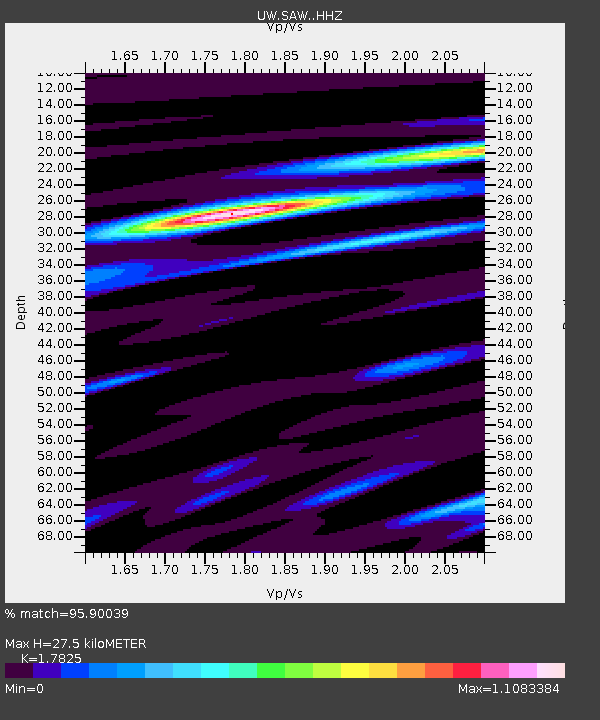
| Estimated Moho Depth: |
27.5 km |
| Estimated Crust Vp/Vs: |
1.78 |
| Assumed Crust Vp: |
6.419 km/s |
| Estimated Crust Vs: |
3.601 km/s |
| Estimated Crust Poisson's Ratio: |
0.27 |
|
| Radial Match: |
95.90039 % |
| Radial Bump: |
369 |
| Transverse Match: |
86.9132 % |
| Transverse Bump: |
400 |
| SOD ConfigId: |
29823551 |
| Insert Time: |
2022-12-18 20:27:04.448 +0000 |
| GWidth: |
2.5 |
| Max Bumps: |
400 |
| Tol: |
0.001 |
|

Signal To Noise
| Channel | StoN | STA | LTA |
| UW:SAW: :HHZ:20221204T19:35:42.950012Z | 27.21063 | 4.3324508E-6 | 1.5921906E-7 |
| UW:SAW: :HHN:20221204T19:35:42.950012Z | 3.8973165 | 7.7638924E-7 | 1.9921124E-7 |
| UW:SAW: :HHE:20221204T19:35:42.950012Z | 6.870876 | 1.2702511E-6 | 1.8487471E-7 |
| Arrivals |
| Ps | 3.4 SECOND |
| PpPs | 12 SECOND |
| PsPs/PpSs | 15 SECOND |


