You are here: Home > Network List > UW - Pacific Northwest Regional Seismic Network Stations List
> Station TBLMT Table Mt, Ellensburg, WA, USA > Earthquake Result Viewer
TBLMT Table Mt, Ellensburg, WA, USA - Earthquake Result Viewer
| Earthquake location: |
Samoa Islands Region |
| Earthquake latitude/longitude: |
-15.7/-172.5 |
| Earthquake time(UTC): |
2022/12/04 (338) 19:24:27 GMT |
| Earthquake Depth: |
148 km |
| Earthquake Magnitude: |
6.9 Mi |
| Earthquake Catalog/Contributor: |
NEIC PDE/at |
|
| Network: |
UW Pacific Northwest Regional Seismic Network |
| Station: |
TBLMT Table Mt, Ellensburg, WA, USA |
| Lat/Lon: |
47.17 N/120.60 W |
| Elevation: |
1088 m |
|
| Distance: |
77.9 deg |
| Az: |
33.298 deg |
| Baz: |
230.81 deg |
| Ray Param: |
0.049617793 |
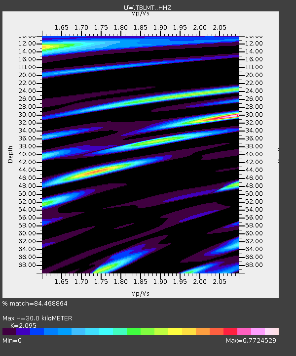
| Estimated Moho Depth: |
30.0 km |
| Estimated Crust Vp/Vs: |
2.10 |
| Assumed Crust Vp: |
6.597 km/s |
| Estimated Crust Vs: |
3.149 km/s |
| Estimated Crust Poisson's Ratio: |
0.35 |
|
| Radial Match: |
84.468864 % |
| Radial Bump: |
400 |
| Transverse Match: |
81.55225 % |
| Transverse Bump: |
400 |
| SOD ConfigId: |
29823551 |
| Insert Time: |
2022-12-18 20:27:31.179 +0000 |
| GWidth: |
2.5 |
| Max Bumps: |
400 |
| Tol: |
0.001 |
|

Signal To Noise
| Channel | StoN | STA | LTA |
| UW:TBLMT: :HHZ:20221204T19:35:37.679993Z | 10.371737 | 4.361162E-6 | 4.2048524E-7 |
| UW:TBLMT: :HHN:20221204T19:35:37.679993Z | 1.7318318 | 7.7510634E-7 | 4.4756442E-7 |
| UW:TBLMT: :HHE:20221204T19:35:37.679993Z | 1.6056749 | 7.5348817E-7 | 4.6926576E-7 |
| Arrivals |
| Ps | 5.1 SECOND |
| PpPs | 14 SECOND |
| PsPs/PpSs | 19 SECOND |


