You are here: Home > Network List > UW - Pacific Northwest Regional Seismic Network Stations List
> Station TREE Summer Lake, OR, USA > Earthquake Result Viewer
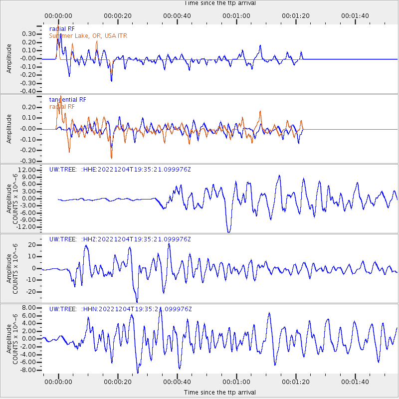
TREE Summer Lake, OR, USA - Earthquake Result Viewer
| Earthquake location: |
Samoa Islands Region |
| Earthquake latitude/longitude: |
-15.7/-172.5 |
| Earthquake time(UTC): |
2022/12/04 (338) 19:24:27 GMT |
| Earthquake Depth: |
148 km |
| Earthquake Magnitude: |
6.9 Mi |
| Earthquake Catalog/Contributor: |
NEIC PDE/at |
|
| Network: |
UW Pacific Northwest Regional Seismic Network |
| Station: |
TREE Summer Lake, OR, USA |
| Lat/Lon: |
42.73 N/120.89 W |
| Elevation: |
1881 m |
|
| Distance: |
75.0 deg |
| Az: |
36.722 deg |
| Baz: |
231.404 deg |
| Ray Param: |
0.05160339 |
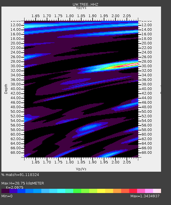
| Estimated Moho Depth: |
28.75 km |
| Estimated Crust Vp/Vs: |
2.10 |
| Assumed Crust Vp: |
6.597 km/s |
| Estimated Crust Vs: |
3.145 km/s |
| Estimated Crust Poisson's Ratio: |
0.35 |
|
| Radial Match: |
91.118324 % |
| Radial Bump: |
356 |
| Transverse Match: |
82.60988 % |
| Transverse Bump: |
400 |
| SOD ConfigId: |
29823551 |
| Insert Time: |
2022-12-18 20:27:43.622 +0000 |
| GWidth: |
2.5 |
| Max Bumps: |
400 |
| Tol: |
0.001 |
|
Signal To Noise
| Channel | StoN | STA | LTA |
| UW:TREE: :HHZ:20221204T19:35:21.099976Z | 6.37362 | 3.263058E-6 | 5.119631E-7 |
| UW:TREE: :HHN:20221204T19:35:21.099976Z | 2.6256995 | 7.0862814E-7 | 2.6988167E-7 |
| UW:TREE: :HHE:20221204T19:35:21.099976Z | 2.5796306 | 8.4578363E-7 | 3.2787005E-7 |
| Arrivals |
| Ps | 4.9 SECOND |
| PpPs | 13 SECOND |
| PsPs/PpSs | 18 SECOND |


