You are here: Home > Network List > TA - USArray Transportable Network (new EarthScope stations) Stations List
> Station K21A Alcova, Casper, WY, USA > Earthquake Result Viewer
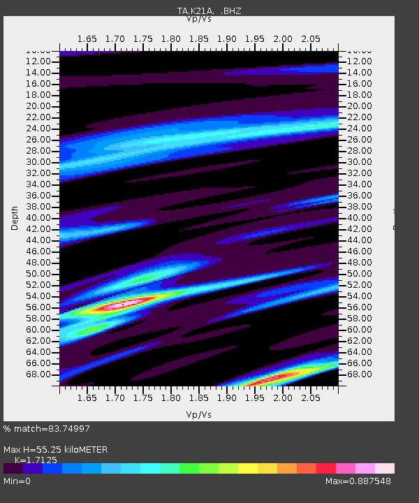
K21A Alcova, Casper, WY, USA - Earthquake Result Viewer
| Earthquake location: |
Near Coast Of Central Chile |
| Earthquake latitude/longitude: |
-36.7/-73.4 |
| Earthquake time(UTC): |
2010/03/05 (064) 11:47:06 GMT |
| Earthquake Depth: |
18 km |
| Earthquake Magnitude: |
6.1 MB, 6.7 MS, 6.6 MW, 6.6 MW |
| Earthquake Catalog/Contributor: |
WHDF/NEIC |
|
| Network: |
TA USArray Transportable Network (new EarthScope stations) |
| Station: |
K21A Alcova, Casper, WY, USA |
| Lat/Lon: |
42.63 N/107.25 W |
| Elevation: |
1960 m |
|
| Distance: |
84.8 deg |
| Az: |
335.601 deg |
| Baz: |
153.251 deg |
| Ray Param: |
0.045240592 |
| Estimated Moho Depth: |
55.25 km |
| Estimated Crust Vp/Vs: |
1.71 |
| Assumed Crust Vp: |
6.178 km/s |
| Estimated Crust Vs: |
3.608 km/s |
| Estimated Crust Poisson's Ratio: |
0.24 |
|
| Radial Match: |
83.74997 % |
| Radial Bump: |
314 |
| Transverse Match: |
65.912704 % |
| Transverse Bump: |
400 |
| SOD ConfigId: |
299721 |
| Insert Time: |
2010-04-26 17:06:00.580 +0000 |
| GWidth: |
2.5 |
| Max Bumps: |
400 |
| Tol: |
0.001 |
|

Signal To Noise
| Channel | StoN | STA | LTA |
| TA:K21A: :BHZ:20100305T11:59:08.350029Z | 2.1021278 | 6.5970147E-7 | 3.138256E-7 |
| TA:K21A: :BHN:20100305T11:59:08.350029Z | 1.1532301 | 2.457637E-7 | 2.1310899E-7 |
| TA:K21A: :BHE:20100305T11:59:08.350029Z | 0.6463294 | 1.39428E-7 | 2.157228E-7 |
| Arrivals |
| Ps | 6.5 SECOND |
| PpPs | 24 SECOND |
| PsPs/PpSs | 30 SECOND |


