You are here: Home > Network List > TA - USArray Transportable Network (new EarthScope stations) Stations List
> Station BRSD Miller, SD, USA > Earthquake Result Viewer
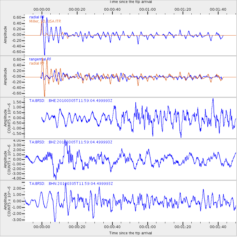
BRSD Miller, SD, USA - Earthquake Result Viewer
*The percent match for this event was below the threshold and hence no stack was calculated.
| Earthquake location: |
Near Coast Of Central Chile |
| Earthquake latitude/longitude: |
-36.7/-73.4 |
| Earthquake time(UTC): |
2010/03/05 (064) 11:47:06 GMT |
| Earthquake Depth: |
18 km |
| Earthquake Magnitude: |
6.1 MB, 6.7 MS, 6.6 MW, 6.6 MW |
| Earthquake Catalog/Contributor: |
WHDF/NEIC |
|
| Network: |
TA USArray Transportable Network (new EarthScope stations) |
| Station: |
BRSD Miller, SD, USA |
| Lat/Lon: |
44.44 N/98.96 W |
| Elevation: |
519 m |
|
| Distance: |
84.0 deg |
| Az: |
341.879 deg |
| Baz: |
159.566 deg |
| Ray Param: |
$rayparam |
*The percent match for this event was below the threshold and hence was not used in the summary stack. |
|
| Radial Match: |
68.38869 % |
| Radial Bump: |
400 |
| Transverse Match: |
48.472 % |
| Transverse Bump: |
400 |
| SOD ConfigId: |
299721 |
| Insert Time: |
2010-04-26 17:07:07.762 +0000 |
| GWidth: |
2.5 |
| Max Bumps: |
400 |
| Tol: |
0.001 |
|
Signal To Noise
| Channel | StoN | STA | LTA |
| TA:BRSD: :BHZ:20100305T11:59:04.499993Z | 2.3744366 | 7.4028844E-7 | 3.1177436E-7 |
| TA:BRSD: :BHN:20100305T11:59:04.499993Z | 1.9186649 | 1.0408937E-6 | 5.4250944E-7 |
| TA:BRSD: :BHE:20100305T11:59:04.499993Z | 1.1371374 | 4.1263658E-7 | 3.6287312E-7 |
| Arrivals |
| Ps | |
| PpPs | |
| PsPs/PpSs | |


