You are here: Home > Network List > XA95 - Missouri to Massachusetts Transect Stations List
> Station MM13 Spiceland, Indiana > Earthquake Result Viewer
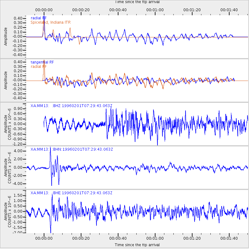
MM13 Spiceland, Indiana - Earthquake Result Viewer
*The percent match for this event was below the threshold and hence no stack was calculated.
| Earthquake location: |
Kuril Islands |
| Earthquake latitude/longitude: |
44.9/146.3 |
| Earthquake time(UTC): |
1996/02/01 (032) 07:18:05 GMT |
| Earthquake Depth: |
180 km |
| Earthquake Magnitude: |
5.7 MB, 6.2 UNKNOWN, 6.2 MW |
| Earthquake Catalog/Contributor: |
WHDF/NEIC |
|
| Network: |
XA Missouri to Massachusetts Transect |
| Station: |
MM13 Spiceland, Indiana |
| Lat/Lon: |
39.83 N/85.31 W |
| Elevation: |
337 m |
|
| Distance: |
83.8 deg |
| Az: |
37.379 deg |
| Baz: |
325.898 deg |
| Ray Param: |
$rayparam |
*The percent match for this event was below the threshold and hence was not used in the summary stack. |
|
| Radial Match: |
68.94673 % |
| Radial Bump: |
400 |
| Transverse Match: |
49.866013 % |
| Transverse Bump: |
400 |
| SOD ConfigId: |
4480 |
| Insert Time: |
2010-02-26 17:53:37.254 +0000 |
| GWidth: |
2.5 |
| Max Bumps: |
400 |
| Tol: |
0.001 |
|
Signal To Noise
| Channel | StoN | STA | LTA |
| XA:MM13: :BHN:19960201T07:29:43.063Z | 7.468687 | 1.552957E-6 | 2.0792905E-7 |
| XA:MM13: :BHE:19960201T07:29:43.063Z | 2.478475 | 6.70787E-7 | 2.7064505E-7 |
| XA:MM13: :BHZ:19960201T07:29:43.063Z | 1.4788179 | 3.290869E-7 | 2.2253377E-7 |
| Arrivals |
| Ps | |
| PpPs | |
| PsPs/PpSs | |


