You are here: Home > Network List > TA - USArray Transportable Network (new EarthScope stations) Stations List
> Station Z29A Hungry Hill Ranch, Wilson, TX, USA > Earthquake Result Viewer
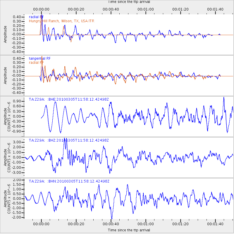
Z29A Hungry Hill Ranch, Wilson, TX, USA - Earthquake Result Viewer
*The percent match for this event was below the threshold and hence no stack was calculated.
| Earthquake location: |
Near Coast Of Central Chile |
| Earthquake latitude/longitude: |
-36.7/-73.4 |
| Earthquake time(UTC): |
2010/03/05 (064) 11:47:06 GMT |
| Earthquake Depth: |
18 km |
| Earthquake Magnitude: |
6.1 MB, 6.7 MS, 6.6 MW, 6.6 MW |
| Earthquake Catalog/Contributor: |
WHDF/NEIC |
|
| Network: |
TA USArray Transportable Network (new EarthScope stations) |
| Station: |
Z29A Hungry Hill Ranch, Wilson, TX, USA |
| Lat/Lon: |
33.26 N/101.71 W |
| Elevation: |
938 m |
|
| Distance: |
74.4 deg |
| Az: |
335.619 deg |
| Baz: |
156.663 deg |
| Ray Param: |
$rayparam |
*The percent match for this event was below the threshold and hence was not used in the summary stack. |
|
| Radial Match: |
76.08831 % |
| Radial Bump: |
400 |
| Transverse Match: |
50.853752 % |
| Transverse Bump: |
400 |
| SOD ConfigId: |
299721 |
| Insert Time: |
2010-04-26 17:07:50.368 +0000 |
| GWidth: |
2.5 |
| Max Bumps: |
400 |
| Tol: |
0.001 |
|
Signal To Noise
| Channel | StoN | STA | LTA |
| TA:Z29A: :BHZ:20100305T11:58:12.42498Z | 2.444323 | 7.162961E-7 | 2.9304476E-7 |
| TA:Z29A: :BHN:20100305T11:58:12.42498Z | 1.4827323 | 5.021349E-7 | 3.3865516E-7 |
| TA:Z29A: :BHE:20100305T11:58:12.42498Z | 0.6431499 | 2.9234278E-7 | 4.5454843E-7 |
| Arrivals |
| Ps | |
| PpPs | |
| PsPs/PpSs | |


