You are here: Home > Network List > CC - Cascade Chain Volcano Monitoring Stations List
> Station OPCH Ohanapecosh Administrative Area > Earthquake Result Viewer
OPCH Ohanapecosh Administrative Area - Earthquake Result Viewer
| Earthquake location: |
Samoa Islands Region |
| Earthquake latitude/longitude: |
-15.4/-173.0 |
| Earthquake time(UTC): |
2022/12/04 (338) 19:24:15 GMT |
| Earthquake Depth: |
36 km |
| Earthquake Magnitude: |
6.7 Mww |
| Earthquake Catalog/Contributor: |
NEIC PDE/us |
|
| Network: |
CC Cascade Chain Volcano Monitoring |
| Station: |
OPCH Ohanapecosh Administrative Area |
| Lat/Lon: |
46.73 N/121.57 W |
| Elevation: |
593 m |
|
| Distance: |
77.1 deg |
| Az: |
33.461 deg |
| Baz: |
230.638 deg |
| Ray Param: |
0.050466344 |
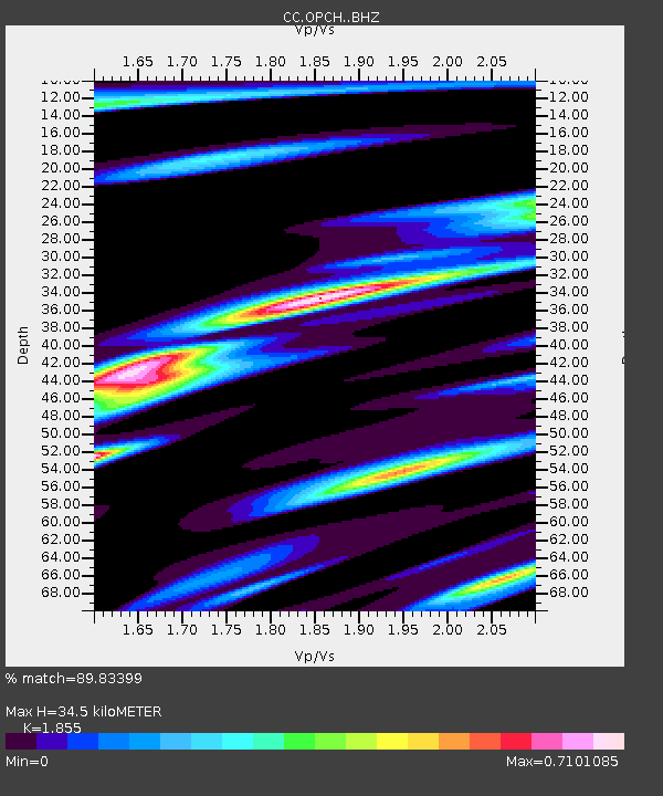
| Estimated Moho Depth: |
34.5 km |
| Estimated Crust Vp/Vs: |
1.86 |
| Assumed Crust Vp: |
6.597 km/s |
| Estimated Crust Vs: |
3.557 km/s |
| Estimated Crust Poisson's Ratio: |
0.30 |
|
| Radial Match: |
89.83399 % |
| Radial Bump: |
365 |
| Transverse Match: |
83.0811 % |
| Transverse Bump: |
400 |
| SOD ConfigId: |
29823551 |
| Insert Time: |
2022-12-18 20:30:41.925 +0000 |
| GWidth: |
2.5 |
| Max Bumps: |
400 |
| Tol: |
0.001 |
|

Signal To Noise
| Channel | StoN | STA | LTA |
| CC:OPCH: :BHZ:20221204T19:35:34.180025Z | 22.406431 | 4.237854E-6 | 1.891356E-7 |
| CC:OPCH: :BHN:20221204T19:35:34.180025Z | 6.1189365 | 7.0711906E-7 | 1.15562415E-7 |
| CC:OPCH: :BHE:20221204T19:35:34.180025Z | 13.408137 | 1.7830234E-6 | 1.3298069E-7 |
| Arrivals |
| Ps | 4.6 SECOND |
| PpPs | 14 SECOND |
| PsPs/PpSs | 19 SECOND |


