You are here: Home > Network List > CC - Cascade Chain Volcano Monitoring Stations List
> Station REM Rembrant, Mount St. Helens > Earthquake Result Viewer
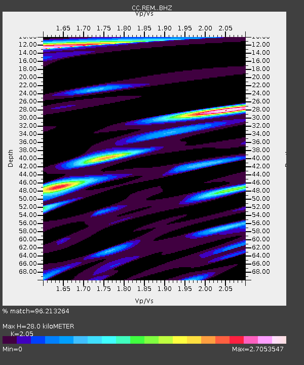
REM Rembrant, Mount St. Helens - Earthquake Result Viewer
| Earthquake location: |
Samoa Islands Region |
| Earthquake latitude/longitude: |
-15.4/-173.0 |
| Earthquake time(UTC): |
2022/12/04 (338) 19:24:15 GMT |
| Earthquake Depth: |
36 km |
| Earthquake Magnitude: |
6.7 Mww |
| Earthquake Catalog/Contributor: |
NEIC PDE/us |
|
| Network: |
CC Cascade Chain Volcano Monitoring |
| Station: |
REM Rembrant, Mount St. Helens |
| Lat/Lon: |
46.20 N/122.19 W |
| Elevation: |
1905 m |
|
| Distance: |
76.5 deg |
| Az: |
33.603 deg |
| Baz: |
230.227 deg |
| Ray Param: |
0.050918557 |
| Estimated Moho Depth: |
28.0 km |
| Estimated Crust Vp/Vs: |
2.05 |
| Assumed Crust Vp: |
6.566 km/s |
| Estimated Crust Vs: |
3.203 km/s |
| Estimated Crust Poisson's Ratio: |
0.34 |
|
| Radial Match: |
96.213264 % |
| Radial Bump: |
400 |
| Transverse Match: |
91.191025 % |
| Transverse Bump: |
400 |
| SOD ConfigId: |
29823551 |
| Insert Time: |
2022-12-18 20:30:57.965 +0000 |
| GWidth: |
2.5 |
| Max Bumps: |
400 |
| Tol: |
0.001 |
|

Signal To Noise
| Channel | StoN | STA | LTA |
| CC:REM: :BHZ:20221204T19:35:30.439974Z | 16.464003 | 7.1215686E-6 | 4.3255392E-7 |
| CC:REM: :BHN:20221204T19:35:30.439974Z | 4.385584 | 2.5118363E-6 | 5.7274843E-7 |
| CC:REM: :BHE:20221204T19:35:30.439974Z | 3.08829 | 3.2711318E-6 | 1.0592049E-6 |
| Arrivals |
| Ps | 4.6 SECOND |
| PpPs | 13 SECOND |
| PsPs/PpSs | 17 SECOND |


