You are here: Home > Network List > CC - Cascade Chain Volcano Monitoring Stations List
> Station SIFT Swift Creek > Earthquake Result Viewer
SIFT Swift Creek - Earthquake Result Viewer
| Earthquake location: |
Samoa Islands Region |
| Earthquake latitude/longitude: |
-15.4/-173.0 |
| Earthquake time(UTC): |
2022/12/04 (338) 19:24:15 GMT |
| Earthquake Depth: |
36 km |
| Earthquake Magnitude: |
6.7 Mww |
| Earthquake Catalog/Contributor: |
NEIC PDE/us |
|
| Network: |
CC Cascade Chain Volcano Monitoring |
| Station: |
SIFT Swift Creek |
| Lat/Lon: |
46.87 N/121.95 W |
| Elevation: |
732 m |
|
| Distance: |
77.0 deg |
| Az: |
33.182 deg |
| Baz: |
230.298 deg |
| Ray Param: |
0.050544173 |
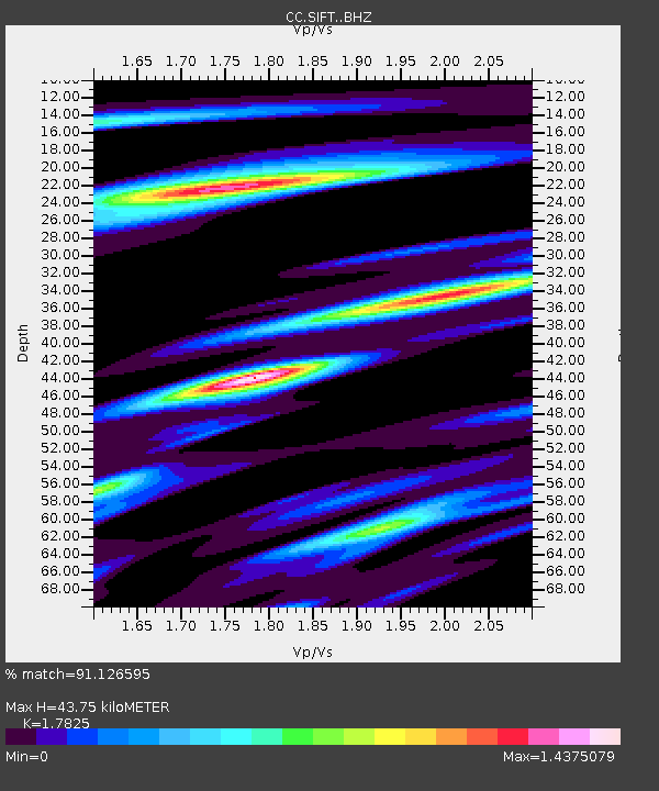
| Estimated Moho Depth: |
43.75 km |
| Estimated Crust Vp/Vs: |
1.78 |
| Assumed Crust Vp: |
6.597 km/s |
| Estimated Crust Vs: |
3.701 km/s |
| Estimated Crust Poisson's Ratio: |
0.27 |
|
| Radial Match: |
91.126595 % |
| Radial Bump: |
400 |
| Transverse Match: |
82.02984 % |
| Transverse Bump: |
400 |
| SOD ConfigId: |
29823551 |
| Insert Time: |
2022-12-18 20:31:04.075 +0000 |
| GWidth: |
2.5 |
| Max Bumps: |
400 |
| Tol: |
0.001 |
|

Signal To Noise
| Channel | StoN | STA | LTA |
| CC:SIFT: :BHZ:20221204T19:35:33.540011Z | 12.204844 | 4.383168E-6 | 3.5913342E-7 |
| CC:SIFT: :BHN:20221204T19:35:33.540011Z | 6.453773 | 1.3275318E-6 | 2.0569857E-7 |
| CC:SIFT: :BHE:20221204T19:35:33.540011Z | 5.765846 | 1.4626321E-6 | 2.5367174E-7 |
| Arrivals |
| Ps | 5.4 SECOND |
| PpPs | 18 SECOND |
| PsPs/PpSs | 23 SECOND |


