You are here: Home > Network List > TA - USArray Transportable Network (new EarthScope stations) Stations List
> Station 332A Millersview, TX, USA > Earthquake Result Viewer
332A Millersview, TX, USA - Earthquake Result Viewer
| Earthquake location: |
Near Coast Of Central Chile |
| Earthquake latitude/longitude: |
-36.7/-73.4 |
| Earthquake time(UTC): |
2010/03/05 (064) 11:47:06 GMT |
| Earthquake Depth: |
18 km |
| Earthquake Magnitude: |
6.1 MB, 6.7 MS, 6.6 MW, 6.6 MW |
| Earthquake Catalog/Contributor: |
WHDF/NEIC |
|
| Network: |
TA USArray Transportable Network (new EarthScope stations) |
| Station: |
332A Millersview, TX, USA |
| Lat/Lon: |
31.38 N/99.74 W |
| Elevation: |
513 m |
|
| Distance: |
72.1 deg |
| Az: |
336.467 deg |
| Baz: |
157.952 deg |
| Ray Param: |
0.053896524 |
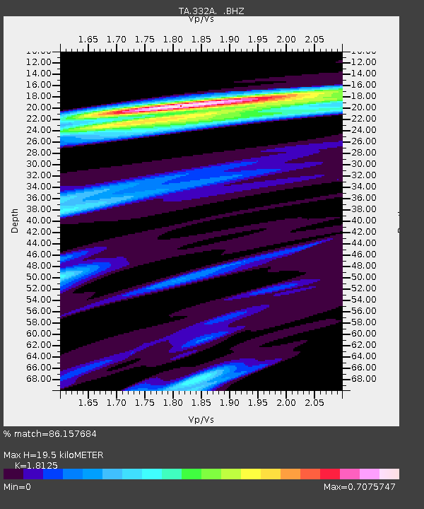
| Estimated Moho Depth: |
19.5 km |
| Estimated Crust Vp/Vs: |
1.81 |
| Assumed Crust Vp: |
6.498 km/s |
| Estimated Crust Vs: |
3.585 km/s |
| Estimated Crust Poisson's Ratio: |
0.28 |
|
| Radial Match: |
86.157684 % |
| Radial Bump: |
400 |
| Transverse Match: |
68.69316 % |
| Transverse Bump: |
400 |
| SOD ConfigId: |
299721 |
| Insert Time: |
2010-04-26 17:08:37.163 +0000 |
| GWidth: |
2.5 |
| Max Bumps: |
400 |
| Tol: |
0.001 |
|
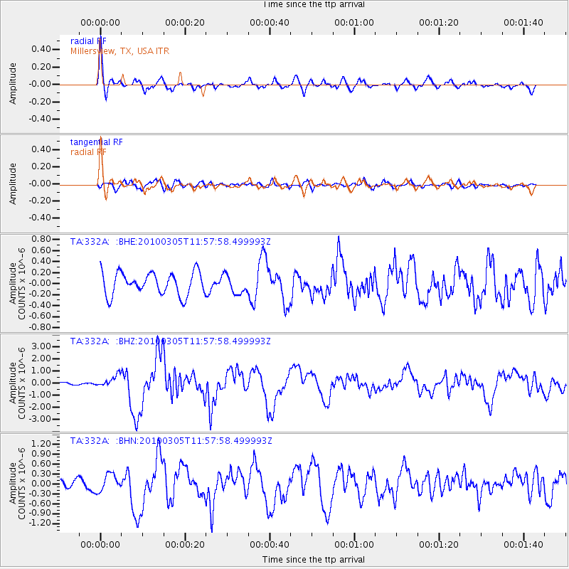
Signal To Noise
| Channel | StoN | STA | LTA |
| TA:332A: :BHZ:20100305T11:57:58.499993Z | 2.433022 | 4.877462E-7 | 2.004693E-7 |
| TA:332A: :BHN:20100305T11:57:58.499993Z | 1.3325366 | 2.5004363E-7 | 1.8764484E-7 |
| TA:332A: :BHE:20100305T11:57:58.499993Z | 0.8330003 | 1.7061613E-7 | 2.0482122E-7 |
| Arrivals |
| Ps | 2.5 SECOND |
| PpPs | 8.1 SECOND |
| PsPs/PpSs | 11 SECOND |


