You are here: Home > Network List > CI - Caltech Regional Seismic Network Stations List
> Station FMP Fort MacArthur Park, Pt. Fermin San Pedro, CA, USA > Earthquake Result Viewer
FMP Fort MacArthur Park, Pt. Fermin San Pedro, CA, USA - Earthquake Result Viewer
| Earthquake location: |
Samoa Islands Region |
| Earthquake latitude/longitude: |
-15.4/-173.0 |
| Earthquake time(UTC): |
2022/12/04 (338) 19:24:15 GMT |
| Earthquake Depth: |
36 km |
| Earthquake Magnitude: |
6.7 Mww |
| Earthquake Catalog/Contributor: |
NEIC PDE/us |
|
| Network: |
CI Caltech Regional Seismic Network |
| Station: |
FMP Fort MacArthur Park, Pt. Fermin San Pedro, CA, USA |
| Lat/Lon: |
33.71 N/118.29 W |
| Elevation: |
89 m |
|
| Distance: |
71.4 deg |
| Az: |
45.856 deg |
| Baz: |
236.137 deg |
| Ray Param: |
0.054312177 |
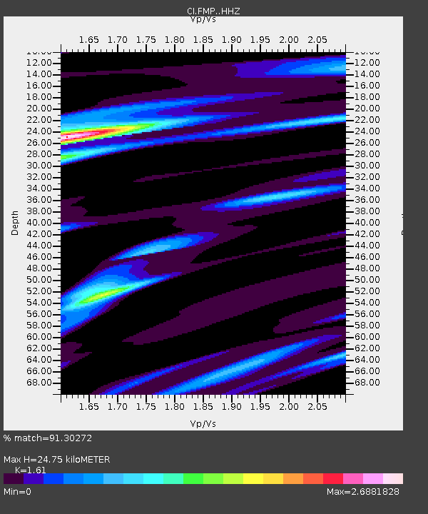
| Estimated Moho Depth: |
24.75 km |
| Estimated Crust Vp/Vs: |
1.61 |
| Assumed Crust Vp: |
6.048 km/s |
| Estimated Crust Vs: |
3.756 km/s |
| Estimated Crust Poisson's Ratio: |
0.19 |
|
| Radial Match: |
91.30272 % |
| Radial Bump: |
400 |
| Transverse Match: |
86.984085 % |
| Transverse Bump: |
400 |
| SOD ConfigId: |
29823551 |
| Insert Time: |
2022-12-18 20:32:21.819 +0000 |
| GWidth: |
2.5 |
| Max Bumps: |
400 |
| Tol: |
0.001 |
|

Signal To Noise
| Channel | StoN | STA | LTA |
| CI:FMP: :HHZ:20221204T19:35:00.748019Z | 12.64558 | 4.687735E-6 | 3.7070143E-7 |
| CI:FMP: :HHN:20221204T19:35:00.748019Z | 1.2320511 | 1.2651807E-6 | 1.0268898E-6 |
| CI:FMP: :HHE:20221204T19:35:00.748019Z | 2.3019433 | 1.6515213E-6 | 7.1744654E-7 |
| Arrivals |
| Ps | 2.6 SECOND |
| PpPs | 10 SECOND |
| PsPs/PpSs | 13 SECOND |


