You are here: Home > Network List > CI - Caltech Regional Seismic Network Stations List
> Station TIN Tinemaha, Big Pine, CA, USA > Earthquake Result Viewer
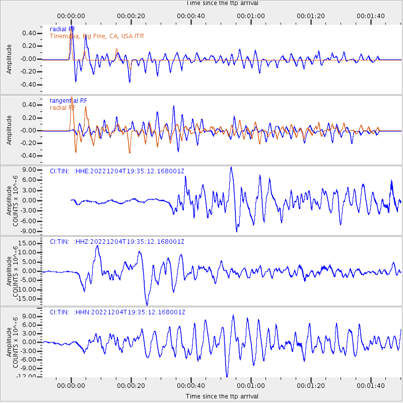
TIN Tinemaha, Big Pine, CA, USA - Earthquake Result Viewer
| Earthquake location: |
Samoa Islands Region |
| Earthquake latitude/longitude: |
-15.4/-173.0 |
| Earthquake time(UTC): |
2022/12/04 (338) 19:24:15 GMT |
| Earthquake Depth: |
36 km |
| Earthquake Magnitude: |
6.7 Mww |
| Earthquake Catalog/Contributor: |
NEIC PDE/us |
|
| Network: |
CI Caltech Regional Seismic Network |
| Station: |
TIN Tinemaha, Big Pine, CA, USA |
| Lat/Lon: |
37.05 N/118.23 W |
| Elevation: |
1197 m |
|
| Distance: |
73.3 deg |
| Az: |
42.996 deg |
| Baz: |
235.307 deg |
| Ray Param: |
0.053035248 |
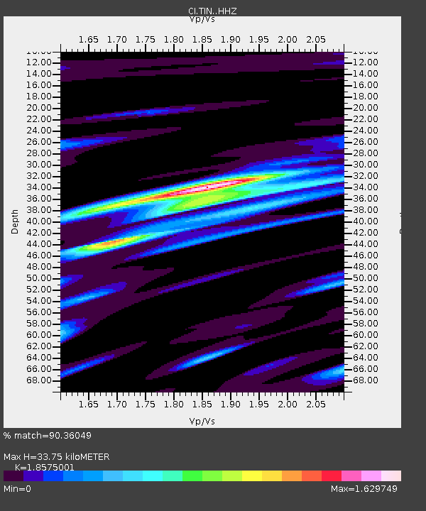
| Estimated Moho Depth: |
33.75 km |
| Estimated Crust Vp/Vs: |
1.86 |
| Assumed Crust Vp: |
6.291 km/s |
| Estimated Crust Vs: |
3.387 km/s |
| Estimated Crust Poisson's Ratio: |
0.30 |
|
| Radial Match: |
90.36049 % |
| Radial Bump: |
400 |
| Transverse Match: |
89.183754 % |
| Transverse Bump: |
400 |
| SOD ConfigId: |
29823551 |
| Insert Time: |
2022-12-18 20:33:54.283 +0000 |
| GWidth: |
2.5 |
| Max Bumps: |
400 |
| Tol: |
0.001 |
|
Signal To Noise
| Channel | StoN | STA | LTA |
| CI:TIN: :HHZ:20221204T19:35:12.168001Z | 18.267824 | 4.3881637E-6 | 2.402127E-7 |
| CI:TIN: :HHN:20221204T19:35:12.168001Z | 5.4453764 | 1.5321775E-6 | 2.8137222E-7 |
| CI:TIN: :HHE:20221204T19:35:12.168001Z | 3.49664 | 1.3921284E-6 | 3.9813318E-7 |
| Arrivals |
| Ps | 4.7 SECOND |
| PpPs | 15 SECOND |
| PsPs/PpSs | 20 SECOND |


