You are here: Home > Network List > CN - Canadian National Seismograph Network Stations List
> Station BRWY Burwash Landing, YT, CA > Earthquake Result Viewer
BRWY Burwash Landing, YT, CA - Earthquake Result Viewer
| Earthquake location: |
Samoa Islands Region |
| Earthquake latitude/longitude: |
-15.4/-173.0 |
| Earthquake time(UTC): |
2022/12/04 (338) 19:24:15 GMT |
| Earthquake Depth: |
36 km |
| Earthquake Magnitude: |
6.7 Mww |
| Earthquake Catalog/Contributor: |
NEIC PDE/us |
|
| Network: |
CN Canadian National Seismograph Network |
| Station: |
BRWY Burwash Landing, YT, CA |
| Lat/Lon: |
61.37 N/139.03 W |
| Elevation: |
802 m |
|
| Distance: |
81.1 deg |
| Az: |
15.79 deg |
| Baz: |
213.023 deg |
| Ray Param: |
0.047756504 |
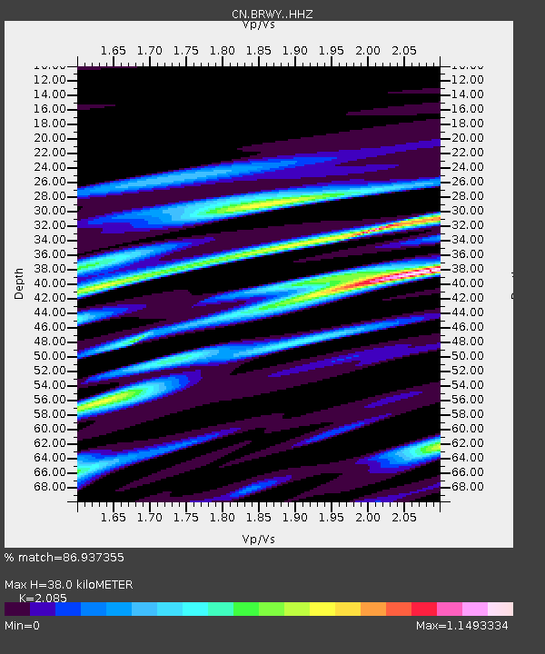
| Estimated Moho Depth: |
38.0 km |
| Estimated Crust Vp/Vs: |
2.09 |
| Assumed Crust Vp: |
6.566 km/s |
| Estimated Crust Vs: |
3.149 km/s |
| Estimated Crust Poisson's Ratio: |
0.35 |
|
| Radial Match: |
86.937355 % |
| Radial Bump: |
400 |
| Transverse Match: |
74.34148 % |
| Transverse Bump: |
400 |
| SOD ConfigId: |
29823551 |
| Insert Time: |
2022-12-18 20:34:24.887 +0000 |
| GWidth: |
2.5 |
| Max Bumps: |
400 |
| Tol: |
0.001 |
|

Signal To Noise
| Channel | StoN | STA | LTA |
| CN:BRWY: :HHZ:20221204T19:35:55.860018Z | 18.209408 | 3.894607E-6 | 2.1387883E-7 |
| CN:BRWY: :HHN:20221204T19:35:55.860018Z | 5.475987 | 1.2217968E-6 | 2.23119E-7 |
| CN:BRWY: :HHE:20221204T19:35:55.860018Z | 4.64598 | 8.071166E-7 | 1.7372365E-7 |
| Arrivals |
| Ps | 6.4 SECOND |
| PpPs | 17 SECOND |
| PsPs/PpSs | 24 SECOND |


