You are here: Home > Network List > TA - USArray Transportable Network (new EarthScope stations) Stations List
> Station H26A Fairpoint, SD, USA > Earthquake Result Viewer
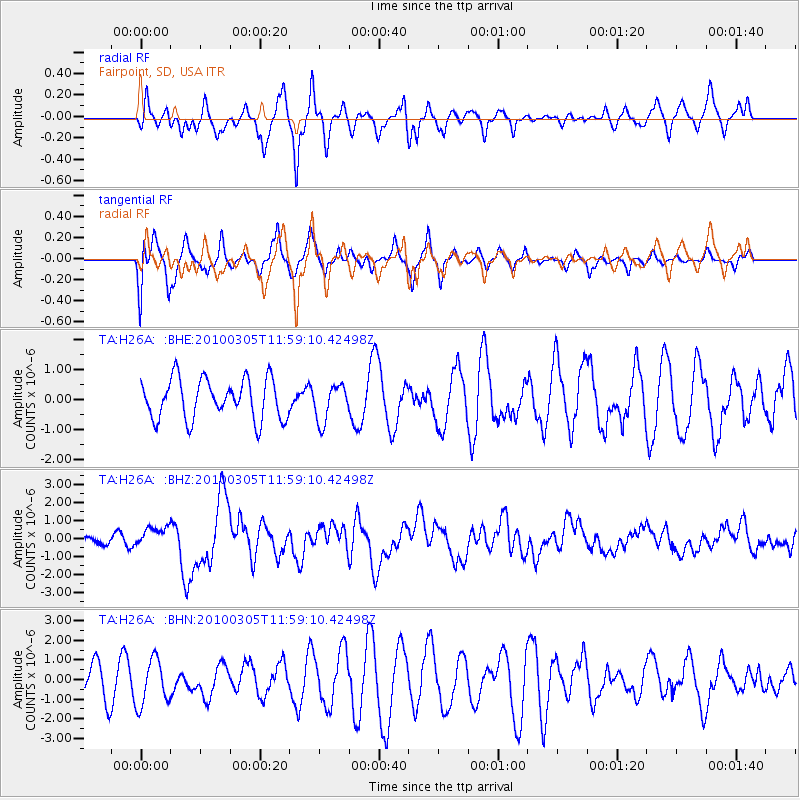
H26A Fairpoint, SD, USA - Earthquake Result Viewer
*The percent match for this event was below the threshold and hence no stack was calculated.
| Earthquake location: |
Near Coast Of Central Chile |
| Earthquake latitude/longitude: |
-36.7/-73.4 |
| Earthquake time(UTC): |
2010/03/05 (064) 11:47:06 GMT |
| Earthquake Depth: |
18 km |
| Earthquake Magnitude: |
6.1 MB, 6.7 MS, 6.6 MW, 6.6 MW |
| Earthquake Catalog/Contributor: |
WHDF/NEIC |
|
| Network: |
TA USArray Transportable Network (new EarthScope stations) |
| Station: |
H26A Fairpoint, SD, USA |
| Lat/Lon: |
44.62 N/102.77 W |
| Elevation: |
879 m |
|
| Distance: |
85.2 deg |
| Az: |
339.4 deg |
| Baz: |
156.664 deg |
| Ray Param: |
$rayparam |
*The percent match for this event was below the threshold and hence was not used in the summary stack. |
|
| Radial Match: |
58.182755 % |
| Radial Bump: |
361 |
| Transverse Match: |
56.986176 % |
| Transverse Bump: |
380 |
| SOD ConfigId: |
299721 |
| Insert Time: |
2010-04-26 17:09:58.104 +0000 |
| GWidth: |
2.5 |
| Max Bumps: |
400 |
| Tol: |
0.001 |
|
Signal To Noise
| Channel | StoN | STA | LTA |
| TA:H26A: :BHZ:20100305T11:59:10.42498Z | 1.6563175 | 5.591161E-7 | 3.3756578E-7 |
| TA:H26A: :BHN:20100305T11:59:10.42498Z | 1.8778427 | 1.19006E-6 | 6.337379E-7 |
| TA:H26A: :BHE:20100305T11:59:10.42498Z | 0.91573334 | 6.1504267E-7 | 6.7163944E-7 |
| Arrivals |
| Ps | |
| PpPs | |
| PsPs/PpSs | |


