You are here: Home > Network List > CN - Canadian National Seismograph Network Stations List
> Station SYMB Survey Mountain, BC, CA > Earthquake Result Viewer
SYMB Survey Mountain, BC, CA - Earthquake Result Viewer
| Earthquake location: |
Samoa Islands Region |
| Earthquake latitude/longitude: |
-15.4/-173.0 |
| Earthquake time(UTC): |
2022/12/04 (338) 19:24:15 GMT |
| Earthquake Depth: |
36 km |
| Earthquake Magnitude: |
6.7 Mww |
| Earthquake Catalog/Contributor: |
NEIC PDE/us |
|
| Network: |
CN Canadian National Seismograph Network |
| Station: |
SYMB Survey Mountain, BC, CA |
| Lat/Lon: |
48.56 N/123.80 W |
| Elevation: |
945 m |
|
| Distance: |
77.2 deg |
| Az: |
31.031 deg |
| Baz: |
228.457 deg |
| Ray Param: |
0.050439157 |
| Estimated Moho Depth: |
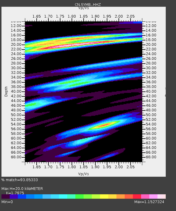
20.0 km |
| Estimated Crust Vp/Vs: |
1.80 |
| Assumed Crust Vp: |
6.566 km/s |
| Estimated Crust Vs: |
3.653 km/s |
| Estimated Crust Poisson's Ratio: |
0.28 |
|
| Radial Match: |
93.85333 % |
| Radial Bump: |
331 |
| Transverse Match: |
84.894165 % |
| Transverse Bump: |
400 |
| SOD ConfigId: |
29823551 |
| Insert Time: |
2022-12-18 20:35:37.381 +0000 |
| GWidth: |
2.5 |
| Max Bumps: |
400 |
| Tol: |
0.001 |
|

Signal To Noise
| Channel | StoN | STA | LTA |
| CN:SYMB: :HHZ:20221204T19:35:34.399996Z | 13.138681 | 4.374204E-6 | 3.3292565E-7 |
| CN:SYMB: :HHN:20221204T19:35:34.399996Z | 4.577456 | 1.2752282E-6 | 2.7858886E-7 |
| CN:SYMB: :HHE:20221204T19:35:34.399996Z | 3.976327 | 1.1243604E-6 | 2.8276358E-7 |
| Arrivals |
| Ps | 2.5 SECOND |
| PpPs | 8.3 SECOND |
| PsPs/PpSs | 11 SECOND |


