You are here: Home > Network List > ET - CERI Southern Appalachian seismic Network Stations List
> Station CPCT Cooper Cave,TN > Earthquake Result Viewer
CPCT Cooper Cave,TN - Earthquake Result Viewer
| Earthquake location: |
Samoa Islands Region |
| Earthquake latitude/longitude: |
-15.4/-173.0 |
| Earthquake time(UTC): |
2022/12/04 (338) 19:24:15 GMT |
| Earthquake Depth: |
36 km |
| Earthquake Magnitude: |
6.7 Mww |
| Earthquake Catalog/Contributor: |
NEIC PDE/us |
|
| Network: |
ET CERI Southern Appalachian seismic Network |
| Station: |
CPCT Cooper Cave,TN |
| Lat/Lon: |
35.45 N/84.52 W |
| Elevation: |
275 m |
|
| Distance: |
97.5 deg |
| Az: |
55.412 deg |
| Baz: |
256.553 deg |
| Ray Param: |
0.04017067 |
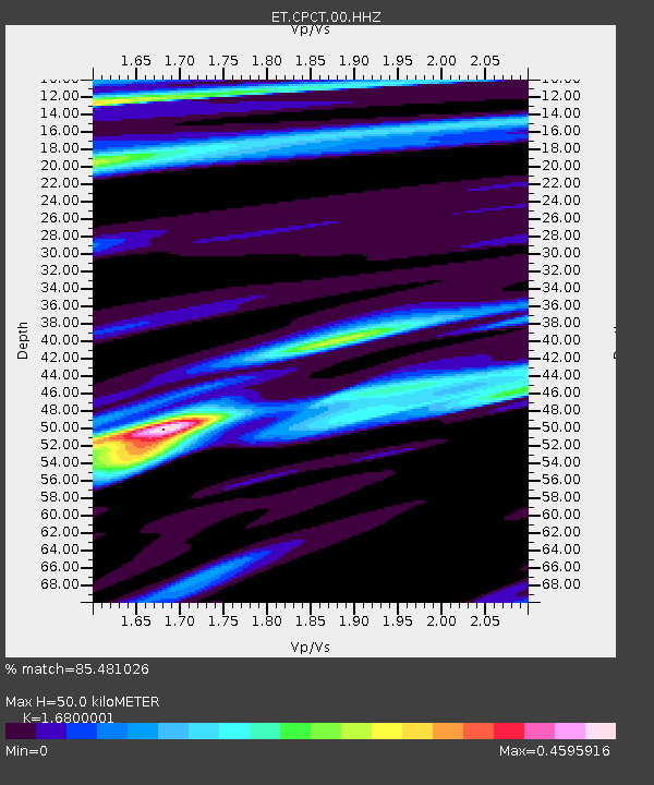
| Estimated Moho Depth: |
50.0 km |
| Estimated Crust Vp/Vs: |
1.68 |
| Assumed Crust Vp: |
6.35 km/s |
| Estimated Crust Vs: |
3.78 km/s |
| Estimated Crust Poisson's Ratio: |
0.23 |
|
| Radial Match: |
85.481026 % |
| Radial Bump: |
400 |
| Transverse Match: |
56.204807 % |
| Transverse Bump: |
400 |
| SOD ConfigId: |
29823551 |
| Insert Time: |
2022-12-18 20:36:37.868 +0000 |
| GWidth: |
2.5 |
| Max Bumps: |
400 |
| Tol: |
0.001 |
|

Signal To Noise
| Channel | StoN | STA | LTA |
| ET:CPCT:00:HHZ:20221204T19:37:14.100008Z | 3.7006927 | 1.0828915E-6 | 2.926186E-7 |
| ET:CPCT:00:HHN:20221204T19:37:14.100008Z | 0.9614243 | 2.0124051E-7 | 2.0931498E-7 |
| ET:CPCT:00:HHE:20221204T19:37:14.100008Z | 1.5253116 | 3.521722E-7 | 2.3088543E-7 |
| Arrivals |
| Ps | 5.5 SECOND |
| PpPs | 21 SECOND |
| PsPs/PpSs | 26 SECOND |


