You are here: Home > Network List > GM - US Geological Survey Networks Stations List
> Station NMP45 New Mexico Permian - Site# W4S5 > Earthquake Result Viewer
NMP45 New Mexico Permian - Site# W4S5 - Earthquake Result Viewer
| Earthquake location: |
Samoa Islands Region |
| Earthquake latitude/longitude: |
-15.4/-173.0 |
| Earthquake time(UTC): |
2022/12/04 (338) 19:24:15 GMT |
| Earthquake Depth: |
36 km |
| Earthquake Magnitude: |
6.7 Mww |
| Earthquake Catalog/Contributor: |
NEIC PDE/us |
|
| Network: |
GM US Geological Survey Networks |
| Station: |
NMP45 New Mexico Permian - Site# W4S5 |
| Lat/Lon: |
32.33 N/103.58 W |
| Elevation: |
1127 m |
|
| Distance: |
81.5 deg |
| Az: |
53.234 deg |
| Baz: |
245.884 deg |
| Ray Param: |
0.047466345 |
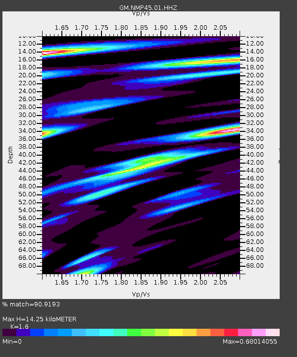
| Estimated Moho Depth: |
14.25 km |
| Estimated Crust Vp/Vs: |
1.60 |
| Assumed Crust Vp: |
6.129 km/s |
| Estimated Crust Vs: |
3.831 km/s |
| Estimated Crust Poisson's Ratio: |
0.18 |
|
| Radial Match: |
90.9193 % |
| Radial Bump: |
400 |
| Transverse Match: |
79.02375 % |
| Transverse Bump: |
400 |
| SOD ConfigId: |
29823551 |
| Insert Time: |
2022-12-18 20:37:36.928 +0000 |
| GWidth: |
2.5 |
| Max Bumps: |
400 |
| Tol: |
0.001 |
|

Signal To Noise
| Channel | StoN | STA | LTA |
| GM:NMP45:01:HHZ:20221204T19:35:58.040011Z | 18.110748 | 4.4212857E-6 | 2.4412495E-7 |
| GM:NMP45:01:HHN:20221204T19:35:58.040011Z | 3.352845 | 4.9601E-7 | 1.4793704E-7 |
| GM:NMP45:01:HHE:20221204T19:35:58.040011Z | 6.3027577 | 1.146755E-6 | 1.8194498E-7 |
| Arrivals |
| Ps | 1.4 SECOND |
| PpPs | 5.9 SECOND |
| PsPs/PpSs | 7.3 SECOND |


