You are here: Home > Network List > GS - US Geological Survey Networks Stations List
> Station ASA5 ASA5 > Earthquake Result Viewer
ASA5 ASA5 - Earthquake Result Viewer
| Earthquake location: |
Samoa Islands Region |
| Earthquake latitude/longitude: |
-15.4/-173.0 |
| Earthquake time(UTC): |
2022/12/04 (338) 19:24:15 GMT |
| Earthquake Depth: |
36 km |
| Earthquake Magnitude: |
6.7 Mww |
| Earthquake Catalog/Contributor: |
NEIC PDE/us |
|
| Network: |
GS US Geological Survey Networks |
| Station: |
ASA5 ASA5 |
| Lat/Lon: |
34.94 N/106.46 W |
| Elevation: |
1835 m |
|
| Distance: |
80.5 deg |
| Az: |
49.814 deg |
| Baz: |
243.762 deg |
| Ray Param: |
0.048197553 |
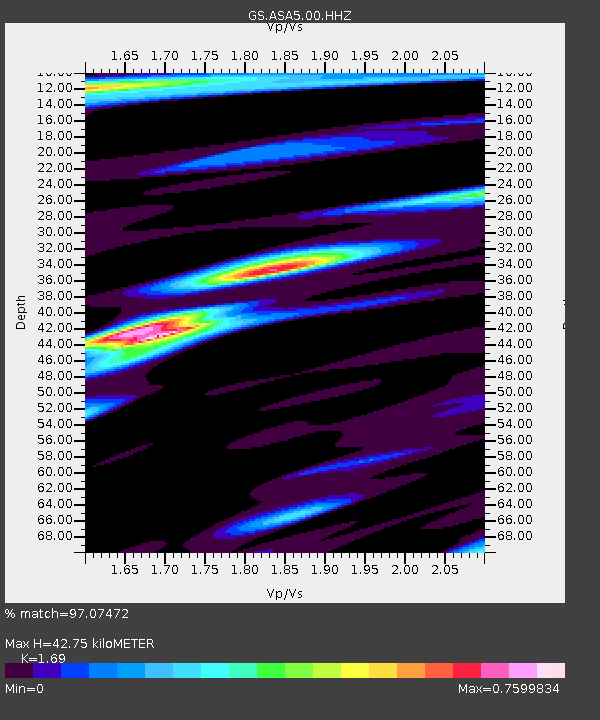
| Estimated Moho Depth: |
42.75 km |
| Estimated Crust Vp/Vs: |
1.69 |
| Assumed Crust Vp: |
6.502 km/s |
| Estimated Crust Vs: |
3.847 km/s |
| Estimated Crust Poisson's Ratio: |
0.23 |
|
| Radial Match: |
97.07472 % |
| Radial Bump: |
356 |
| Transverse Match: |
93.93009 % |
| Transverse Bump: |
400 |
| SOD ConfigId: |
29823551 |
| Insert Time: |
2022-12-18 20:37:51.579 +0000 |
| GWidth: |
2.5 |
| Max Bumps: |
400 |
| Tol: |
0.001 |
|

Signal To Noise
| Channel | StoN | STA | LTA |
| GS:ASA5:00:HHZ:20221204T19:35:52.389986Z | 28.089973 | 4.053111E-6 | 1.442903E-7 |
| GS:ASA5:00:HH1:20221204T19:35:52.389986Z | 4.3096967 | 6.610321E-7 | 1.5338252E-7 |
| GS:ASA5:00:HH2:20221204T19:35:52.389986Z | 8.707285 | 1.3088766E-6 | 1.5031972E-7 |
| Arrivals |
| Ps | 4.7 SECOND |
| PpPs | 17 SECOND |
| PsPs/PpSs | 22 SECOND |


