You are here: Home > Network List > TA - USArray Transportable Network (new EarthScope stations) Stations List
> Station 533A Kerrville, TX, USA > Earthquake Result Viewer
533A Kerrville, TX, USA - Earthquake Result Viewer
| Earthquake location: |
Near Coast Of Central Chile |
| Earthquake latitude/longitude: |
-36.7/-73.4 |
| Earthquake time(UTC): |
2010/03/05 (064) 11:47:06 GMT |
| Earthquake Depth: |
18 km |
| Earthquake Magnitude: |
6.1 MB, 6.7 MS, 6.6 MW, 6.6 MW |
| Earthquake Catalog/Contributor: |
WHDF/NEIC |
|
| Network: |
TA USArray Transportable Network (new EarthScope stations) |
| Station: |
533A Kerrville, TX, USA |
| Lat/Lon: |
30.07 N/99.04 W |
| Elevation: |
556 m |
|
| Distance: |
70.6 deg |
| Az: |
336.55 deg |
| Baz: |
158.339 deg |
| Ray Param: |
0.05484588 |
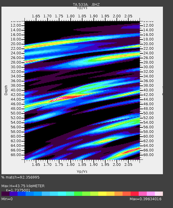
| Estimated Moho Depth: |
43.75 km |
| Estimated Crust Vp/Vs: |
1.74 |
| Assumed Crust Vp: |
6.498 km/s |
| Estimated Crust Vs: |
3.74 km/s |
| Estimated Crust Poisson's Ratio: |
0.25 |
|
| Radial Match: |
92.356995 % |
| Radial Bump: |
400 |
| Transverse Match: |
68.83301 % |
| Transverse Bump: |
400 |
| SOD ConfigId: |
299721 |
| Insert Time: |
2010-04-26 17:12:13.931 +0000 |
| GWidth: |
2.5 |
| Max Bumps: |
400 |
| Tol: |
0.001 |
|

Signal To Noise
| Channel | StoN | STA | LTA |
| TA:533A: :BHZ:20100305T11:57:49.825005Z | 2.6538713 | 4.4535548E-7 | 1.6781351E-7 |
| TA:533A: :BHN:20100305T11:57:49.825005Z | 1.9906566 | 2.1968455E-7 | 1.1035783E-7 |
| TA:533A: :BHE:20100305T11:57:49.825005Z | 1.4848878 | 1.9020634E-7 | 1.2809474E-7 |
| Arrivals |
| Ps | 5.2 SECOND |
| PpPs | 18 SECOND |
| PsPs/PpSs | 23 SECOND |


