You are here: Home > Network List > IW - Intermountain West Stations List
> Station PLID Pearl Lake, Idaho, USA > Earthquake Result Viewer
PLID Pearl Lake, Idaho, USA - Earthquake Result Viewer
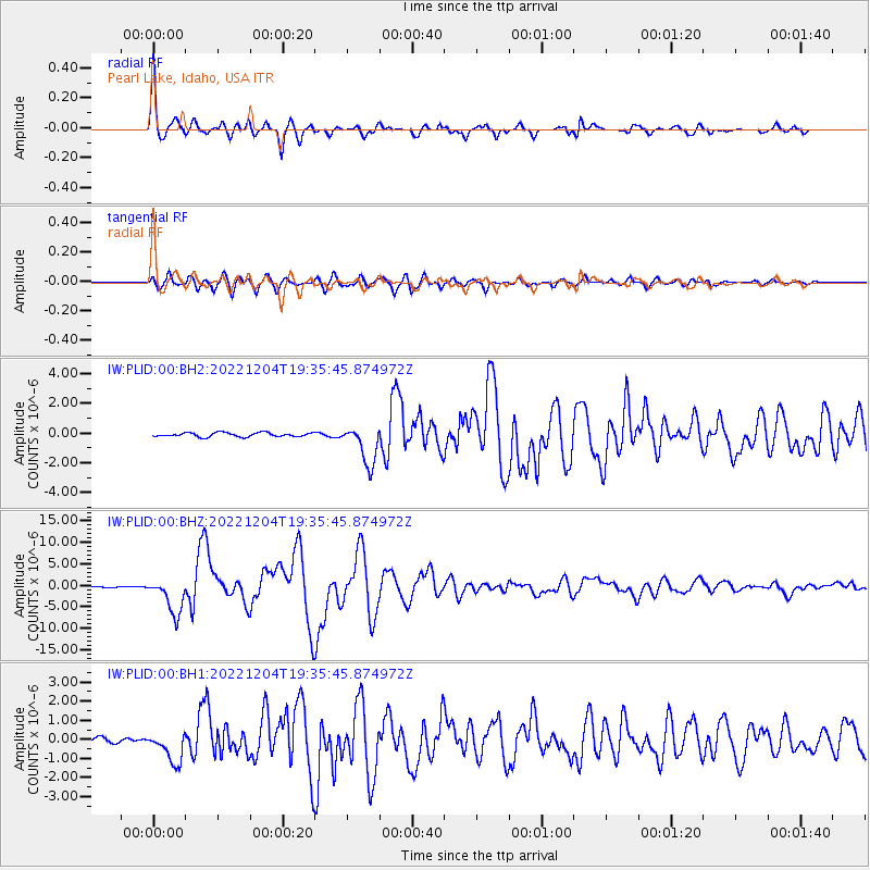
| Earthquake location: |
Samoa Islands Region |
| Earthquake latitude/longitude: |
-15.4/-173.0 |
| Earthquake time(UTC): |
2022/12/04 (338) 19:24:15 GMT |
| Earthquake Depth: |
36 km |
| Earthquake Magnitude: |
6.7 Mww |
| Earthquake Catalog/Contributor: |
NEIC PDE/us |
|
| Network: |
IW Intermountain West |
| Station: |
PLID Pearl Lake, Idaho, USA |
| Lat/Lon: |
45.09 N/116.00 W |
| Elevation: |
2164 m |
|
| Distance: |
79.3 deg |
| Az: |
37.191 deg |
| Baz: |
235.391 deg |
| Ray Param: |
0.049031306 |
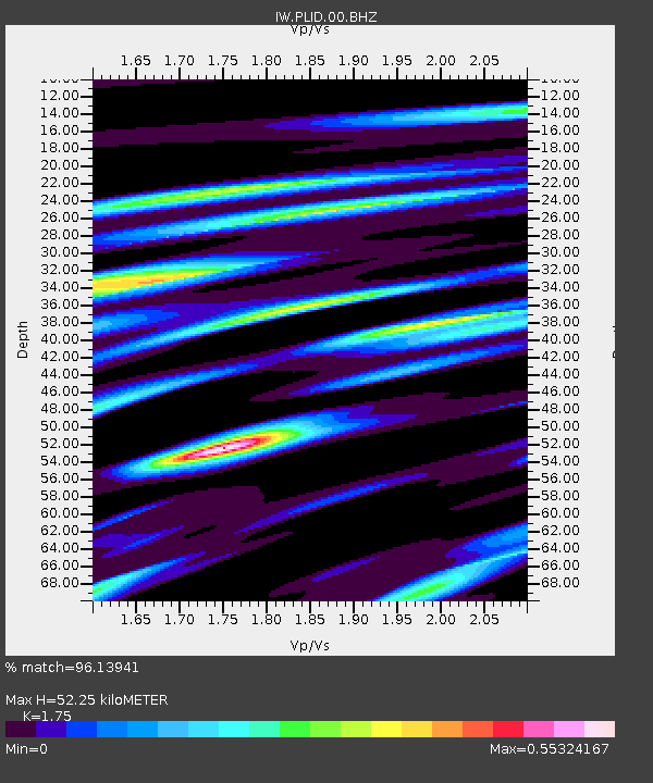
| Estimated Moho Depth: |
52.25 km |
| Estimated Crust Vp/Vs: |
1.75 |
| Assumed Crust Vp: |
6.571 km/s |
| Estimated Crust Vs: |
3.755 km/s |
| Estimated Crust Poisson's Ratio: |
0.26 |
|
| Radial Match: |
96.13941 % |
| Radial Bump: |
400 |
| Transverse Match: |
86.94305 % |
| Transverse Bump: |
400 |
| SOD ConfigId: |
29823551 |
| Insert Time: |
2022-12-18 20:40:14.558 +0000 |
| GWidth: |
2.5 |
| Max Bumps: |
400 |
| Tol: |
0.001 |
|
Signal To Noise
| Channel | StoN | STA | LTA |
| IW:PLID:00:BHZ:20221204T19:35:45.874972Z | 42.701565 | 4.2533966E-6 | 9.9607504E-8 |
| IW:PLID:00:BH1:20221204T19:35:45.874972Z | 6.6492414 | 8.13532E-7 | 1.2234959E-7 |
| IW:PLID:00:BH2:20221204T19:35:45.874972Z | 9.796765 | 1.3463975E-6 | 1.3743286E-7 |
| Arrivals |
| Ps | 6.2 SECOND |
| PpPs | 21 SECOND |
| PsPs/PpSs | 27 SECOND |


